Jul 222014
 

As detailed here, over a 40-year contract period (which is expected to be extended “in perpetuity”), the proponent would receive a subsidy of over $100 million from the provincial government.

The proponent estimated that the proposed station would generate 20.77 GW•h of electricity per year. Given that a typical home uses about 12,100 kW•h/year, the proposed generating station would provide power to about 1,710 homes. Such a typical home pays about $1,625/year (exclusing HST) for this power.

So the provincial subisdy would be about ($100,000,000 / 40 / 1,710 =) $1,462 per home per year.

If only the homes that received this power paid for it, their annual electricity cost would increase by (1,462/1,625 =) 91% to pay this subsidy.

So one way of looking at this deal is that the provincial government has decided that the 1,710 homes that would receive the power from this proposed generating station would have the honour of paying through their provincial taxes a subsidy of about $1,500 per year, for 40 years, to this private developer.

It would therefore appear that:

  • The power consumers of Ontario should know that the real cost of the electicity they use from generating stations such as that proposed for Bala is actually double what they see on their electricity bill.
  • Given that the proponent has apparently spent over $2,000,000 pursuing this opportunity so far, it is clearly a much richer deal for proponents than is necessary.
Jul 212014
 

As detailed in our article here, we have many specific, often technical, concerns, and the province’s responses have not actually answered the questions.

For example:

  • The local volunteer fire department has not been contacted to know what budget, training, or equipment they may need to handle emergencies. The province simply says call 911, as if magically skilled people will respond. Of course, in Toronto, such resources are available, but not in Muskoka.
  • The province states that the proposed generating station would occupy a similar footprint as the Bala #2 generating station that used to be on the site, when in fact the proposed generating station would have a footprint 25 times that of the Bala #2 generating station.
  • The province states that marine navigation would not be affected. But Transport Canada has not evaluated the downstream conditions and have not provided their final assessment.

We detailed this concerns in this Open Letter to Premier Wynne.

As shown below, the province’s reply is that “It is regrettable that you found previous correspondence unsatisfactory”. They simply don’t have an answer to the solid concerns we have stated.


MNR5385MC-2014-937
June 20, 2014
 
Mr. Mitchell Shnier
 
Dear Mr. Shnier:
 
Premier Kathleen Wynne shared with the Honourable David Orazietti, Minister of Natural Resources, your letter regarding the proposed hydro-electric project in Bala.
 
It is regrettable that you found previous correspondence unsatisfactory.  The Minister of the Environment has confirmed that Swift River Energy Ltd., the proponent of the waterpower project, completed the Class Environmental Assessment (EA) for the project and could proceed with the project, subject to other permits and approvals.
 
The Ministry of Natural Resources has issued an approval under the Lakes and Rivers Improvement Act (LRIA) for the location of the facility on a 0.07 hectare Crown land site. Regional and district staff will review the plans and specifications for the project that have been submitted by Swift River Energy Ltd.
 
I am confident that this review will result in ensuring that the proposed plans and specifications meet the requirements of the LRIA and that the project’s Class Environmental Assessment’s conditions of approval and commitments made by the proponent through the Class Environmental Assessment process will be met.
 
Sincerely,
 
Original signed by Carrie Hayward
 
 
Carrie Hayward
Assistant Deputy Minister
Regional Operations Division
 
c:      Premier Kathleen Wynne
        Her Worship Alice Murphy, Mayor of the Township of Muskoka Lakes
Jul 202014
 

Background

Firstly, it is clear that explorer and cartographer David Thompson was just finding existing portages, he didn’t make any. That is, the “Indians” (as he calls the people already there) had already made and continued to use all the portages needed for his travels.

Thompson’s Journal

As noted on page 8 of this letter, Thompson was travelling upstream on the Moon River and on August 13, 1837 when he first approached what is now called the Bala north falls, Thompson thought that what we now call the south channel was the portage, as he notes “the CP (carrying place – what we now call a portage) is in a bay about 80 or 100 yards to the right of the falls”.

But after he camps overnight and examines the area he realizes that the real portage is actually between Bala north falls and the south channel, as he writes “the CP close on the right of the portage is an old channel were water still runs when high”.

So we know that the Bala Portage is between what is now the Bala north falls and the south channel.

Thompson’s Map

Below a section of the map Thompson created as he travelled through what is now called Bala. At the very left is Gaunt Bay / Trafalgar Bay on the Moon River, in the centre is what we now call the Bala north falls, but is here called “12th Fall, 19 ft” (as they were the twelvth falls from Georgian Bay and had a drop of 19 feet). To the right is what we now call Bala Bay (Thompson calls this Swamp Ground Lake, the earliest name for Lake Muskoka) on Lake Muskoka.

Some observations:

  • The south channel was not carrying water when Thompson travelled through, so isn’t shown on the map.
  • The Mill Stream / Burgess Creek also did not exist yet. Either it also only carried water during spring freshet and other times of high water in Lake Muskoka, or it was blasted by Thomas Burgess for his construction of the Bala #1 generating station (and possibly a Mill before that).

In lakes and wider rivers, Thompson shows his path with a dotted line, so Thompson’s map below confirms the Bala Portage was south of the Bala north falls. Note that all of what is now the Bala north channel would have been rapids at the time, so the upstream end of the portage was on Bala Bay (what is now called Diver’s Point).

As this area has been changed over time (major changes were the construction of the CPR railway in 1907, and the construction of the highway bypass in 1965), the exact path of the portage would have also changed – but the shortest and easiest route would have continued to be south of the Bala north falls.

Aerial Photograph

This photograph below would have been taken between 1924 (when the Bala #2 generating station was built, or maybe later as the second story of Carr’s Arcadia has been built) and 1958 (when the Bala #2 generating station was taken out of operation). The photograph shows a path south of (that is, to the right of) the Bala #2 generating station, showing portaging would have continued south of the Bala north falls, and that there was ample room for the portage to continue to be used while the Bala #2 generating station was in operation. As the Bala north dam is now in place, so the Bala north channel is navigable, the upstream end of the portage may have often been beside Purk’s Place as that would be closer than Diver’s Point.

Current Situation

Due to the province’s construction of the highway bypass, at the Moon River end, the only path which can now be used for the Bala Portage is to pass through the highway guardrail directly south of the Muskoka Road 169 bridge over the Bala north channel. And even if there was an opening in the guardrail farther south along Muskoka Road 169, the province’s construction of the highway bypass resulted in the slope of the land up to the highway being too steep for portaging south of the guardrail opening.

Jul 182014
 

The proponent has requested (several times) to use Township’s Portage Landing site during construction. This is the part of Burgess Island west of Muskoka Road 169 and south of the proposed construction site. The proponent would cut down all the trees, pile it full of blasted rock, drive construction vehicles all over it, set-up a huge crane, locate a settling tank the size of a large truck, and on and on. They say they would restore it, but it would never be the same.

To help visualize what the proponent would do to this natural and historic location, here is a photograph of the site now, and something like what it would look like for a very long time (click on it for a larger view).

During the proposed construction, the proponent also wants to use both the Precambrian Shield parking lot and the south half of the Don’s Bakery parking lot to store construction materials and vehicles.

We say “no, thank you”, if you want to make a mess, do it on only the land you have rights to, not the Township’s land.

Jul 172014
 

David Thompson was a famous surveyor and cartographer who lived from 1770 to 1857. In 1837 he was asked by the British government to find and survey a route from Lake Huron to the Ottawa River as the construction of a canal (complete with locks, so boats would not need to be portaged) was being considered.

During this exploration, Thompson kept a very detailed Journal, which is available for viewing on microfilm at the Archives of Ontario in Toronto. Some transcript and explanation of when he travelled through what is now called Bala is on pages 7 to 9, 18, and 19 of this letter.

Library and Archives Canada in Ottawa has two maps he created from this trip, and these are available for viewing there on microfiche. These are reproduced below (you can click on any of the images for a larger view).

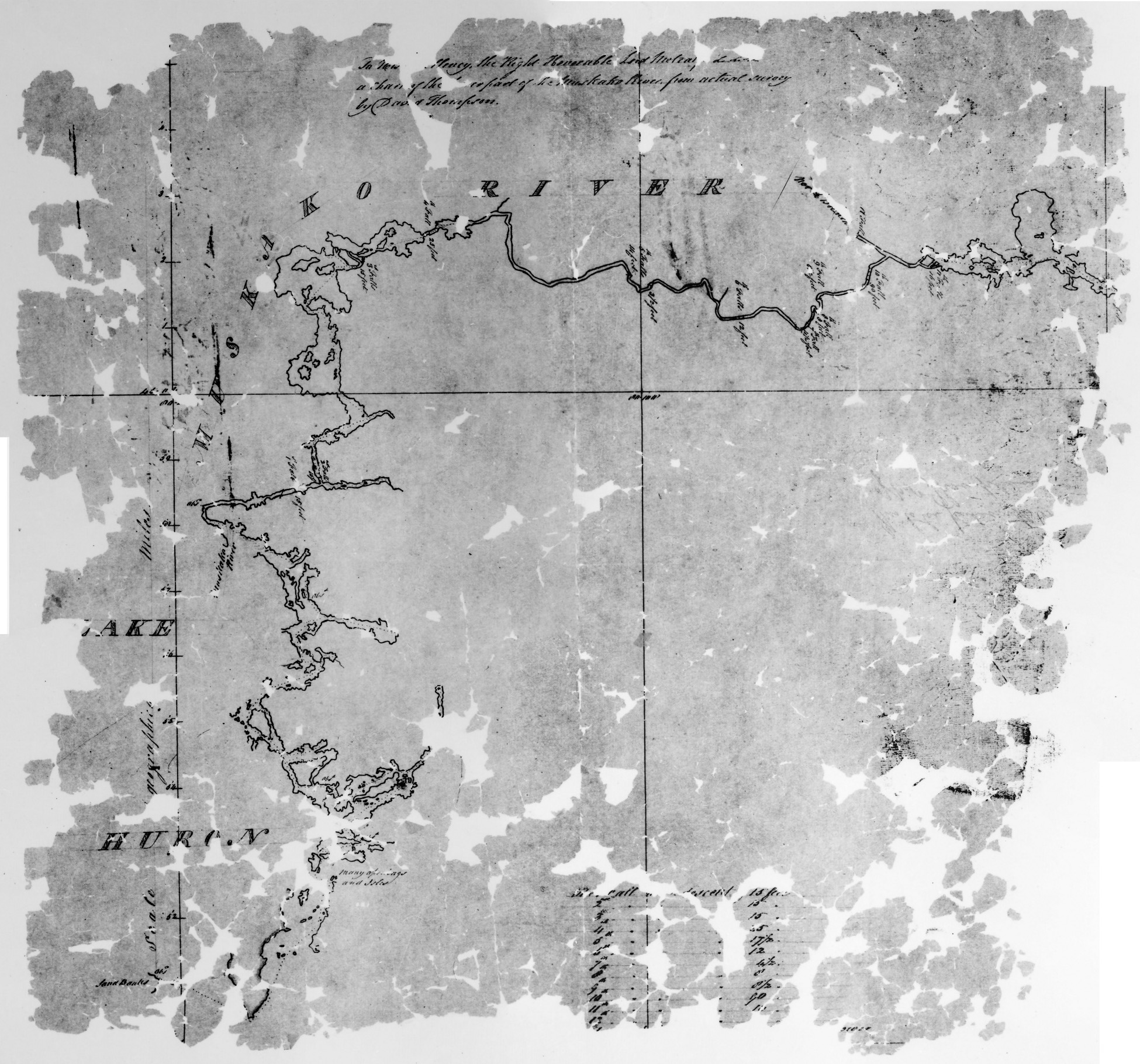
The map below is from microfiche NMC8907:

  • At the top the map is entitled “To His Excellency, the Right Honorable Lord Metcalf &c &c &c a chart of the Lower part of the Muskako River, from actual survey by David Thompson.” The “&c” was the abbreviation then used for etcetera (now more commonly abbreviated “etc.”), to take the place of reciting the many titles and honours the Lord would have.
  • The table at the bottom of the map summarizes the drop of each falls he encountered, referring to each falls by numbering them starting at the beginning of his expedition, with the first falls closest to Lake Huron. He then travelled by canoe upstream towards Bala and beyond.
  • For lakes and wider sections of rivers he showed his exact route with a dotted line (click on any of the images to see this more clearly).
  • The map shows the Muskako River (what we now call the Musquash River, which splits from the Moon River closer to Bala) from Lake Huron (we now call this part Georgian Bay) to what we now call Bala. Unfortunately, the part of the map at Bala is damaged and not readable.

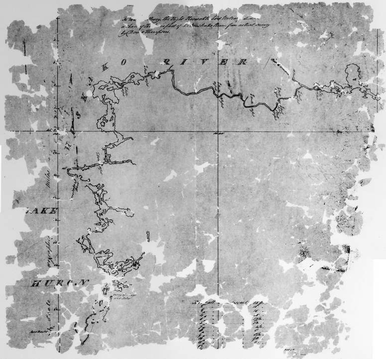
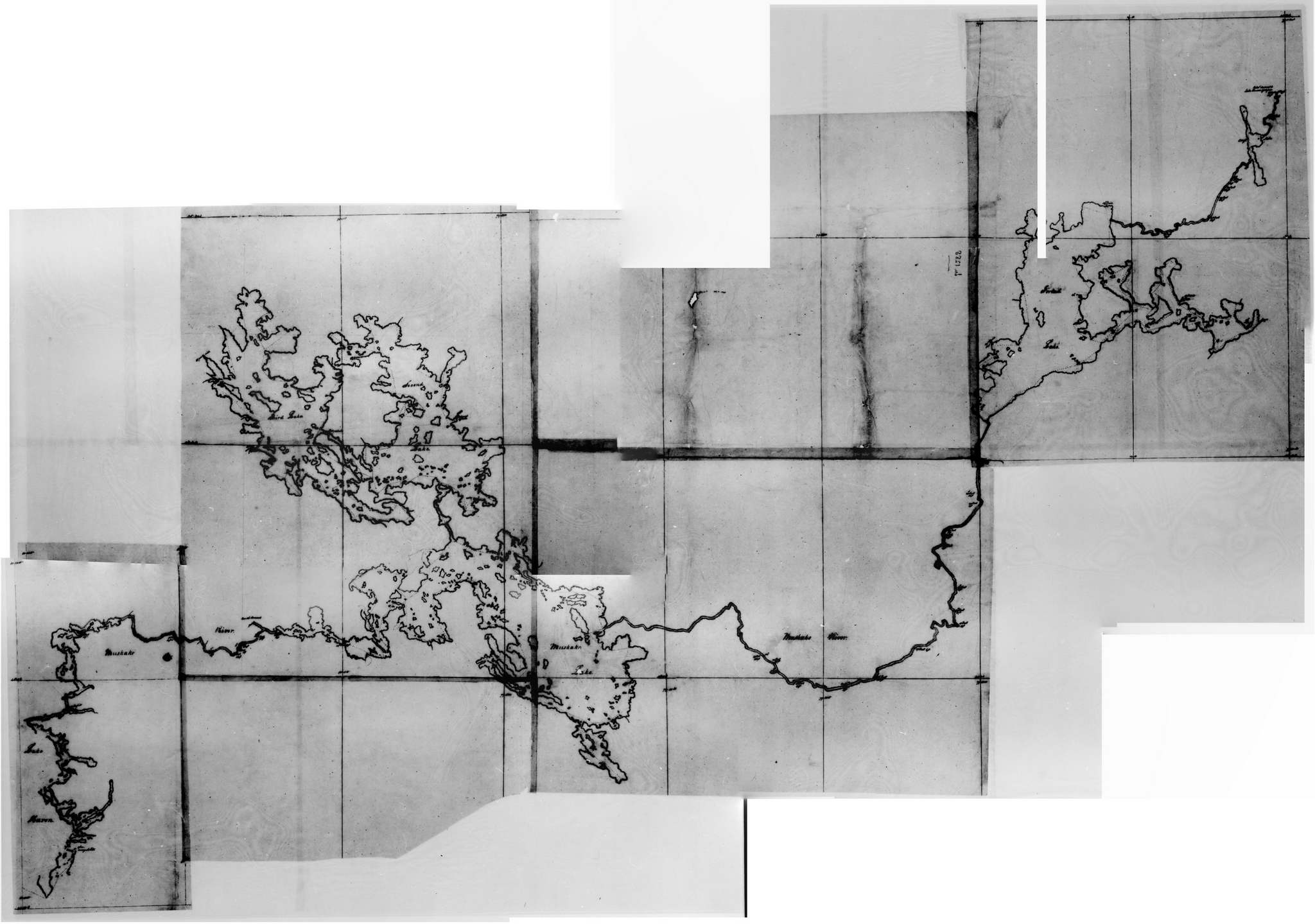
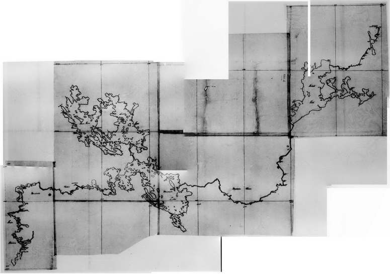
The maps below are all from Thompson’s other map of this expedition, and are from microfiches NMC119075. Library and Archives Canada has given this map the title “Map of the Muskoka River and Lake Huron to Cross Lake” (Cross Lake indeed has a “cross” shape, but is now called Oxtongue Lake).

It may be that Thompson actually made this map during the expedition, and the one above entitled to Lord Metcalf … was a copy he made for presentation to the British government (given the title and table added).

As the microfiche readers at the archives would only show a portion of this microfiche at a time (also, this map spanned two microfiches), many images recorded had to be merged, which is why this map appears to have been pieced together.

This map begins at Lake Huron at the lower-left, continues up the Musquash River, shows Bala, the three main lakes, then the Muskoka River flows through the Lake of Bays, and finally at the very top-right is Oxtongue Lake.

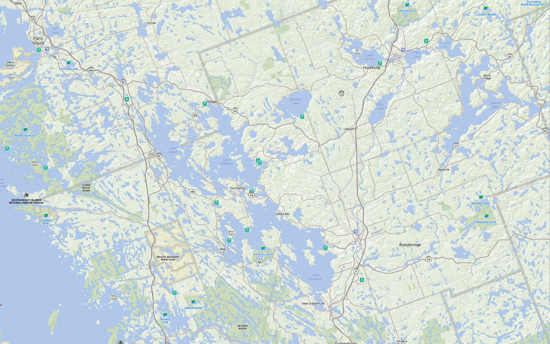
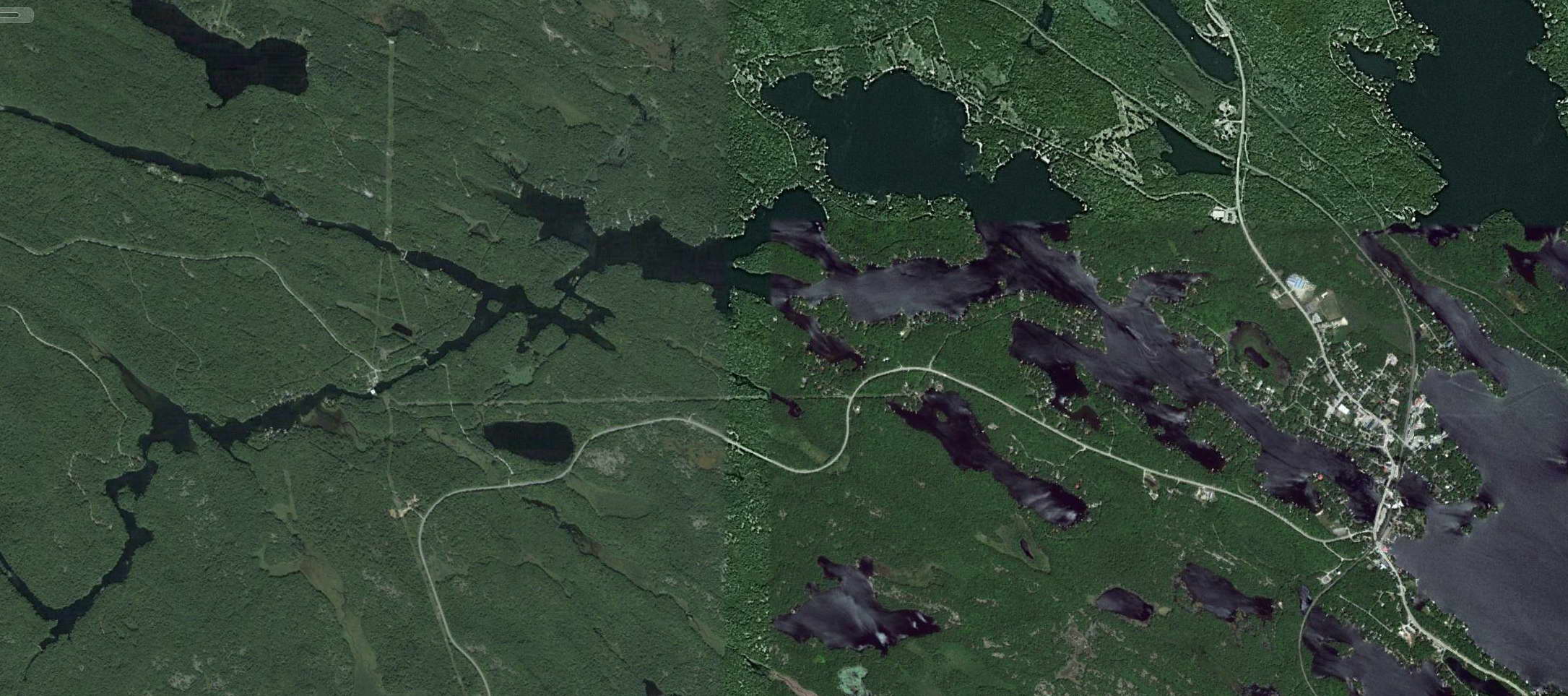
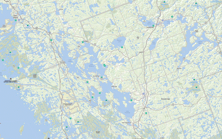
The image below shows the same geographic area as Thompson’s map, but on a current map from the Ministry of Natural Resources. This shows how fantastically accurate Thompson’s map is, though due to most of the lake water levels being increased by the many dams and other water control structures, the shorelines of most lakes will now be different.

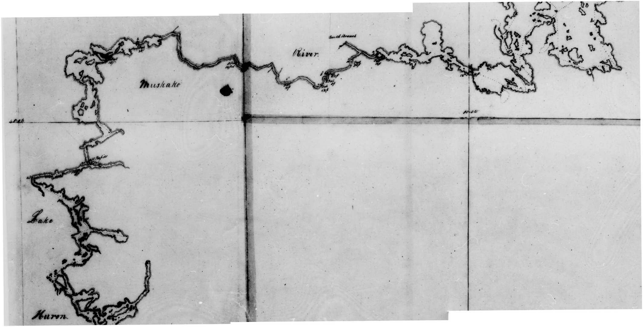
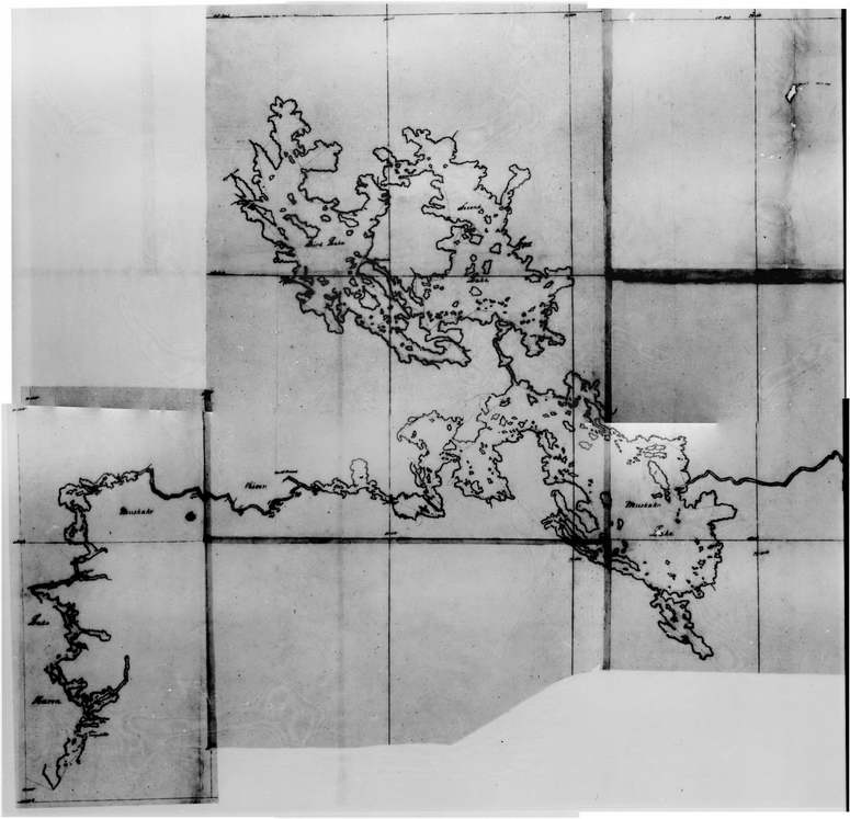
Back to Thompson’s map, here showing just the lower-left portion. If you click on it for a larger view and then use your browser to zoom in (either by clicking again, or maybe pressing “Ctrl +”), you can see:

  • Lake Muskoka is labelled Muskako Lake
  • Lake Rosseau is called Second Lake
  • Lake Joseph is called Third Lake

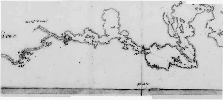
The section of map below shows just the lower-left of that above, from Lake Huron to Bala Bay. What we now call the Musquash River is called the Muskako River, and where the Moon River splits off to the north he has called it North Branch. The dotted line showing his actual route can be seen by clicking on this image, and shows he travelled along the south side of Bala Bay (as the water level would have been lower then, the islands are larger), and left Bala Bay through the channel to the west of Wanilah Island.

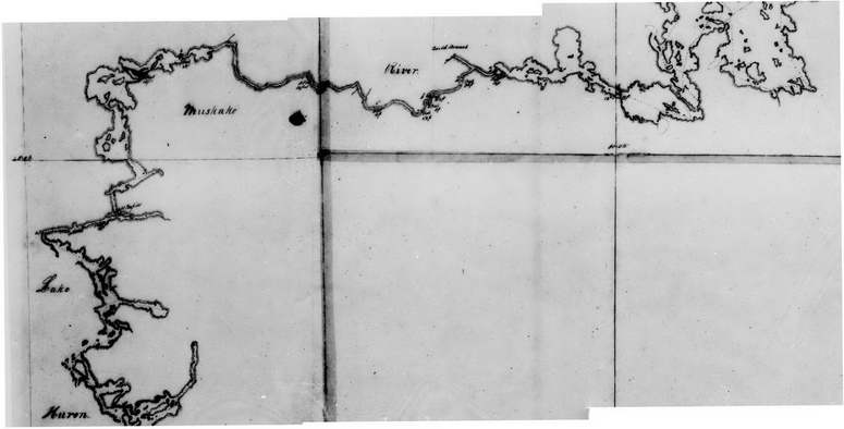
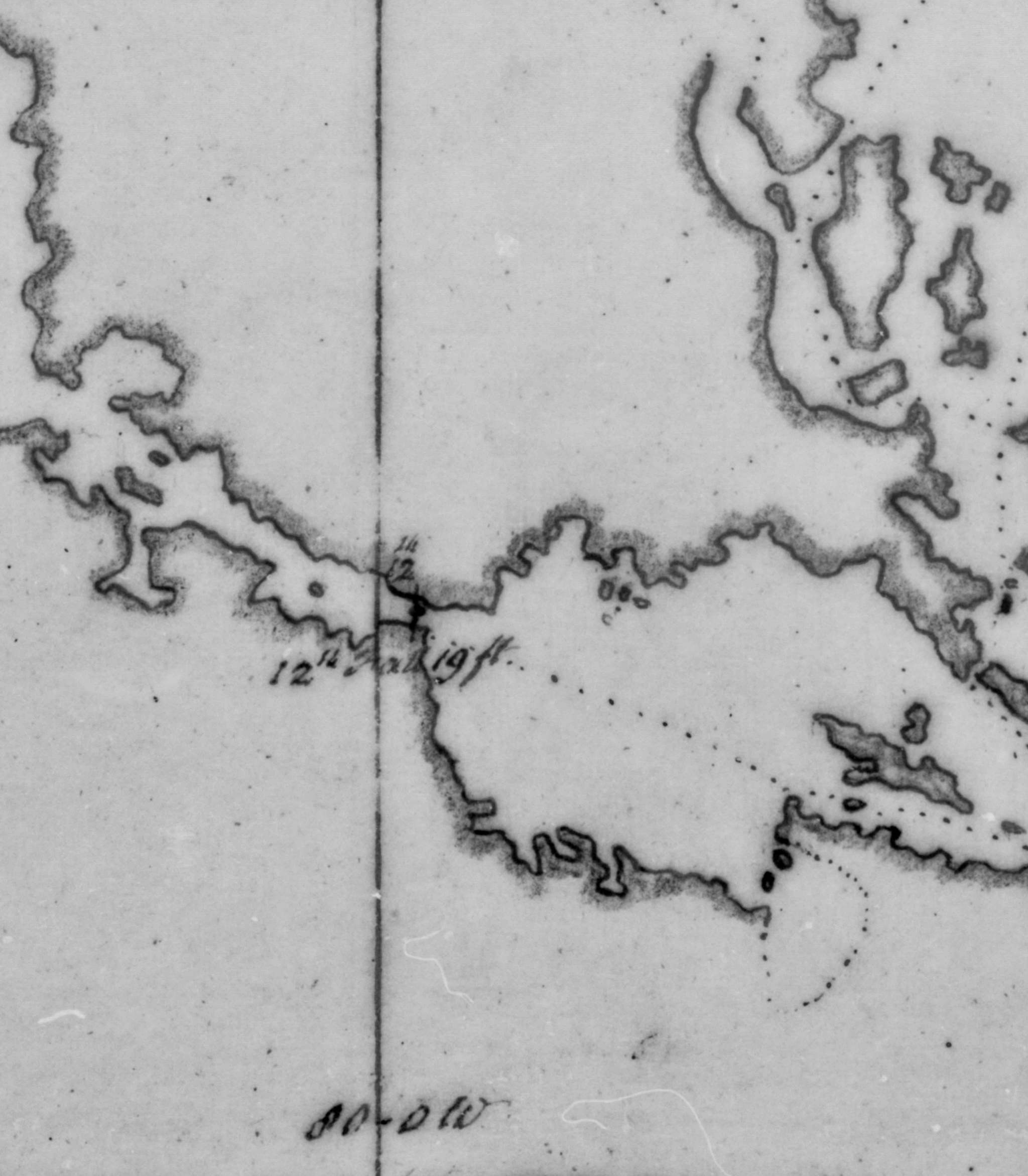
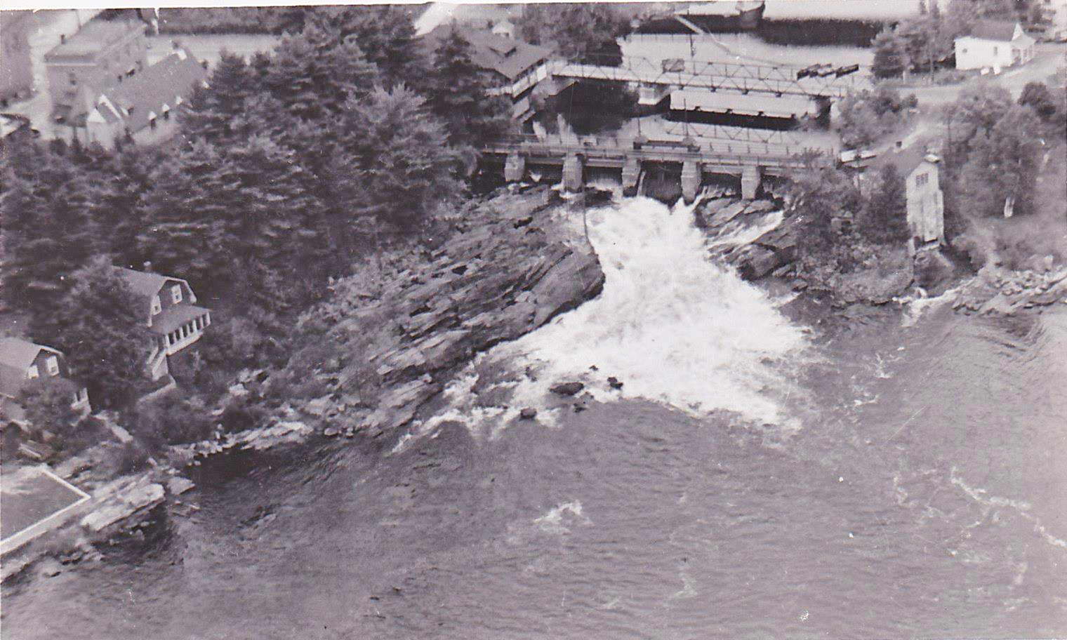
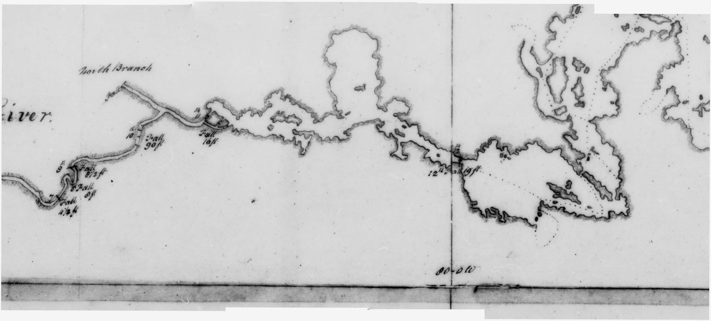
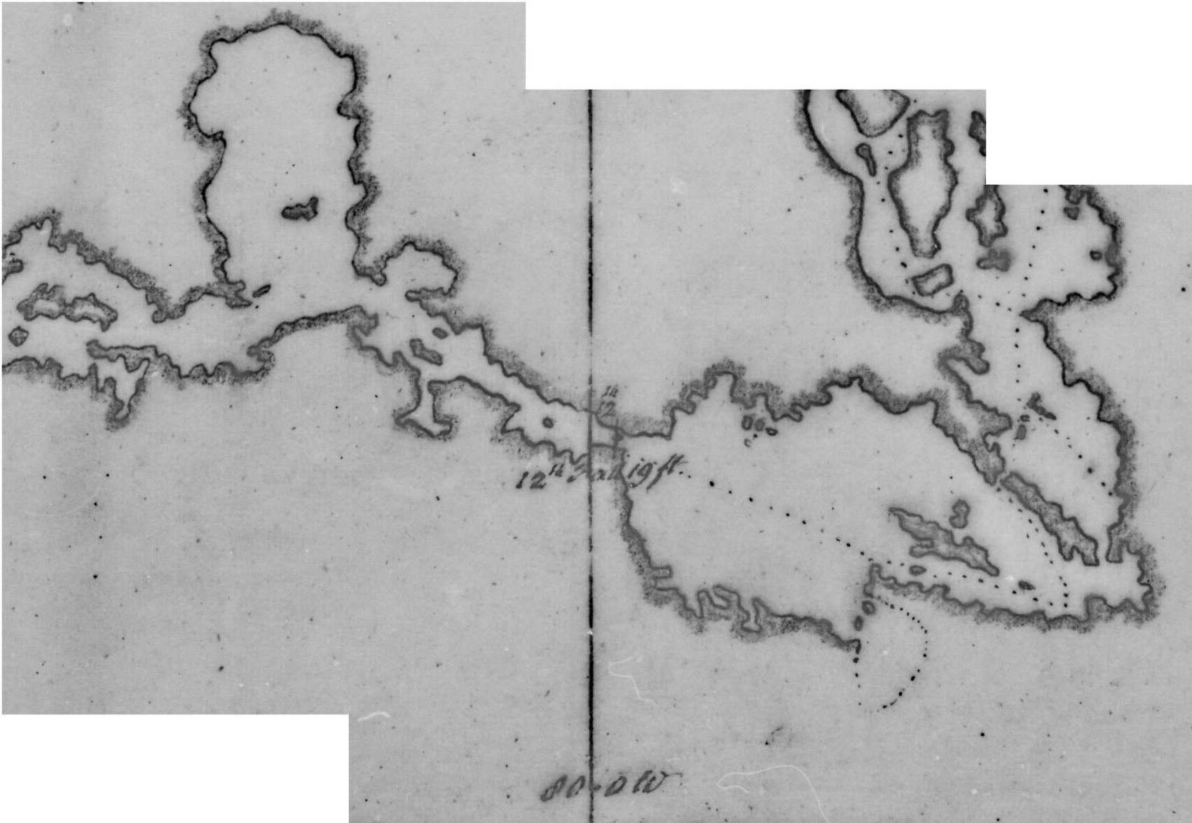
Below is just the Bala Reach section of the above map. Thompson explored the Moon River only as far downstream as what is now the Moon Dam. Trafalgar Bay / Gaunt Bay was smaller as the water level in the Moon River would have been lower without the Moon Dam and Ragged Rapids generating station dam. What is now Ragged Rapids is shown as being the 10th Fall (he often writes the “th” directly above the number) with a drop of 90 feet. What is now the Moon Chutes is shown as being the 11th Fall, and what is now the Bala north falls is the 12th Fall, with a drop of 19 feet.

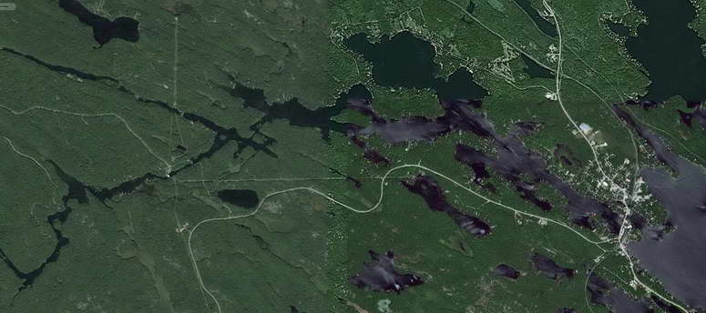
Below is the Google Earth view of the west side of the Bala Reach of the Moon River. While the shoreline is different due to the changed water levels, the orientation and scale of the map are remarkably accurate.

Finally, the image below zooms-in, centred on the Bala north falls (click on it for a larger view). While the Moon River was narrow enough that he did not show the dotted line of his route before he reached Bala, it is clear that when he finished portaging around the “12th Falls”, he entered Bala Bay from the south side of what is now the Bala north falls.

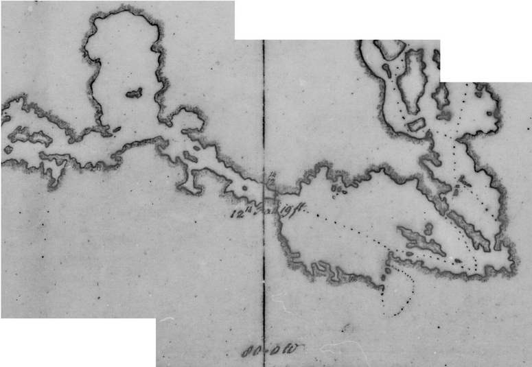
That is, Thompson’s map confirms the text of his Journal, that the Bala portage was on the south side of what is now the Bala north falls.

Jul 152014
 

Mitchell Shnier of SaveTheBalaFalls.com was interviewed on radio station CKTB 610 in St. Catherines by Tim Denis during his morning show on July 14, 2014. You can listen to the 6-minute interview here (never mind the host gave Mitchell a new surname, the rest of the interview is very good).

Mitchell Shnier was interviewed on radio station CFRB 1010 in Toronto on the Late Shift with Bill Hayes on July 16, 2014. You can listen to the 15-minute interview here (there is a brief introduction, and after the interview there’s a call-in caller and after a break some additional commentary from the host).

Jul 132014
 

In their Saturday July 12, 2014 edition, the Globe and Mail newspaper published a full-page article on the concern that the proposed hydro-electric generating station would obstruct Bala’s traditional and historic portage.

  • You can read the article here (with the large print and photographs, it is 9 pages), and the public’s comments posted by the next day are here. The July 22, 2014 article on the Judicial Review appeal decision is here.
     
  • The full-page image of the article is here (zoom-in to read it, starting half-way down the left side of the page). The July 19, 2014 Letters to the Editor are here. The July 22, 2014 article on the Judicial Review appeal decision is here.
     
  • The on-line version is here, with a follow-up article here. The July 19, 2014 Letters to the Editor are here. The July 22, 2014 article on the Judicial Review appeal decision is here.
Jul 062014
 

Summary
The proponent would be increasing the water level of Lake Muskoka in order to increase their profits. Which would be fine, except this increases the risk of flooding Lake Muskoka when unexpectedly heavy rains occur.
 

Detail
The proponent’s 2009 Environmental Screening report detailed the changes the proponent would request to the Muskoka River Water Management Plan.

The dashed line in this diagram shows the “Target Operating Level” for Lake Muskoka, which is the water level (in metres above sea level) the proponent would be attempting to maintain for Lake Muskoka. As you see, it varies throughout the year for various reasons (for example, it is lowered in advance of spring freshet to allow for the rapid increase when the snow begins to melt), and this is the same water level the Ministry of Natural Resources currently attempts to maintain.

However, the proponent proposes a “Best Management Zone”, shown in more detail in the inset image, which would allow the proponent to raise the water level of Lake Muskoka by 4 cm during August, and by 5 cm during September.

In addition, the proponent would be allowed to cycle the operation of the proposed generating station, for example, by stopping flow through the generating station during the night and morning (increasing the water level of Lake Muskoka), and running it at up to ⅓ capacity during the afternoons (decreasing the water level of Lake Muskoka). This cycling would change the water level of Lake Muskoka by perhaps 2 cm each day. As detailed in Section 9.12, the required water level is reported as a 24-hour average, so the actual water level could be 1 cm lower than the top of the Best Management Zone at night, and 1 cm higher in the afternoon (so, 5 cm higher during August and 6 cm higher during September), and it would still be considered in compliance.

But as shown by the green band, the proponent could raise water levels even further and still be in the “Compliance band”, which would normally be to allow delays while staff get to the dams to insert and remove stop-logs. But the proposed generating station would be automatically- and remotely-operated, and is now said to have a higher capacity (96 m³/s) than originally-proposed (79 m³/s). So the output could change more rapidly to try to not exceed the Complaince Zone, which would increase even more the danger to those in the water at the base of the Bala north falls.

This higher water level would be at the times power is generated (and higher water levels mean greater power generated and greater profits to the proponent), but only during the months that the proposed generating station would have the least flow and therefore least profits. So this appears to be only for the purpose of generating more revenue for the proponent. Which is fine, except higher water levels also result in less margin to allow for heavy rains, which as we’ve seen, seem to be occurring more often lately.

So there would be more shoreline erosion and more risk of flooding just so the proponent can increase their revenue.

Jul 052014
 

In July, 2014, the proponent began making automated telephone calls to people’s homes and cottages in Muskoka.

In a lame attempt to circumvent Canada’s telemarketing rules, the proponent presents their unsolicited call as a survey, even though their call is actually commercial promotion, which would be illegal.

The black text below is a transcript of the core part of their call, with our comments in red (click on it for a larger view).