Jul 032013
 

Check this out. Four 5/16″-diameter bolts, set in concrete, with sharp ends pointed up. Not only is this a tripping hazard, but if someone impaled their knee, it would be horribly painful and damaging.

Most alarmingly, the Ontario Ministry of Natural Resources constructed danger to the public on their Crown land south of the north Bala dam in late June, 2013. And without any warning, signage, or marking (other than the coloured string), they left this exactly as shown (photograph below was taken Sunday afternoon June 30), throughout the Canada Day long weekend, when hundreds of people were expected to be visiting the falls, both during the day, and after dark for the Canada Day festivities.

While the MNR staff are mostly in Bracebridge or Parry Sound making these terrible decisions, the proponent had a drilling crew at this exact location (for example, they installed the test access post just to the right of it) in the days before this long weekend, and they too left this accident waiting to happen. This is unprofessional and inexcusable. These are not people we want in our neighbourhood.

This outrageous disregard for public safety is exactly what both the Ministry of the Environment and the MNR are showing through their support for the proponent’s current “Alternative 1A proposal” which would direct the treacherously fast and turbulent water exiting the generating station towards the long-time in-water recreational area at the base of the Bala north falls (more detail here).

Government should be for the people, not against the people.

May 072013
 

In advance of the 2013 spring freshet (where there was flooding – by far, the highest in memory), Ministry of Natural Resources staff did not draw down the water level of Lake Muskoka as much as they could have. This would indicate that the magnitude of high-flow events cannot be predicted.

This is a concern as during the construction of the proposed hydro-electric generating station at the Bala falls, the north channel would need to be obstructed by a cofferdam. And as we have shown here, historical flow data for the Moon River shows there would only be a short 15-week period (and this only during the lower-flow period of the summer) when this obstruction would not risk flooding Lake Muskoka.

We have therefore sent this letter to the Minister of Natural Resources, requesting a peer-reviewed report showing the construction could be done without risk to private property, public infrastructure, or area businesses.

May 032013
 

Summary
As shown below, the Ministry of Natural Resources has a poor record of anticipating peak flow events. For example, in 2013 they could have reduced the water level of Lake Muskoka by an additional 12.5″, and this would have reduced the flooding of Lake Muskoka and the Moon River.

This is a concern as the proponent has asked the MNR to approve the installation of a cofferdam which would obstruct most of the north channel during the proposed construction. As we have shown here, high flows occur throughout the year, and this cofferdam could flooding of Lake Muskoka and damage the highway bridge over the north channel.

The MNR should therefore not provide location approval for the proposed project as the current design would risk damage to; private property, public infrastructure, and the local businesses and economy.

Detail
As we’ve seen, the flooding of Lake Muskoka, the Moon River and other waterbodies in the spring of 2013 was the worst in memory. The Ministry of Natural Resources has responsibility for managing water levels for these watersheds, and part of this work is to reduce the water level in Lake Muskoka (called “draw-down”) in advance of spring to accomodate the high flows expected.

The Water Survey of Canada program collects and makes available water flow and level information. Since 2002 they have had a station recording the water level of Lake Muskoka at Beaumaris, and the graphs below (click on them for a larger view) show the water levels for 2002 through 2011, and for 2012 to 2013. Also shown on these graphs are the actual maximum draw-down in the spring, and the subsequent peak water level for each year, all given as metres above sea level (MASL).

As can be seen, the water levels are reduced by different amounts each spring. Staff at the MNR determine this draw-down according to many factors:

  • The amount of snowfall which has yet to melt.
  • How rapidly this snow is expected to melt.
  • How frozen the ground is, as this determines how rapidly the water will end up in lakes and rivers.

There are several water level limits established by the Muskoka River Water Management Plan. For example, page 12-106 defines the Normal Operating Zone for Lake Muskoka to be from 224.6 MASL to 225.75 MASL.

In 2013 the water level of Lake Muskoka peaked at 226.156 MASL, which is 16″ above the upper limit of the Normal Operating Zone.

The graph below shows the actual maximum draw-down and subsequent peak water levels for Lake Muskoka each spring for the past 11 years. The Normal Operating Zone is between the horizontal blue lines.

As shown, the MNR does draw-down water levels by different amounts each year. For example, in 2008 the water was drawn-down more than most years, however spring flooding still occurred. What this graph shows us is that the water could have been drawn down by an additional 2.8″, which would have reduced the subsequent flooding, which was 7.2″ above the Normal Operating Zone.

For 2013, the MNR could have drawn-down Lake Muskoka by 12.5″ more than they did, and this would have reduced the subsequent flooding, which was 16″ above the Normal Operating Zone.

Summary
As shown above, the MNR has a poor record of anticipating high-flow events for Lake Muskoka. And as shown here, the construction of the proposed hydro-electric generating station at the Bala falls would require obstructing most of the north channel during times when high-flow events have occurred in the recent past. The MNR should therefore not provide location approval for the proposed project as it would risk damage to private property, public infrastructure, and the local businesses and economy.

Apr 092013
 

The public has not been informed of the risks presented by the proponent’s new “Alternative 1A” proposal, or how these would be mitigated.

And we note that the Ministry of Natural Resources’ Lakes and Rivers Improvement Act Administrative Guide specifies in Section 3.2 notes that “effective public consultation” is required for the Location Approval.

Accordingly, we have sent this letter to the Minister of Natural Resources


Apr 042013
 

Despite the detail provided in our letter here, the Ministry of Natural Resources replied that for the portage to warrant protection under Section 65(4) of the Public Lands Act, they require “early surveys, maps or documents” as historical evidence that this portage was “in place prior to the initial Crown patent”.

Accordingly, we provided this letter, which provides the requested information.

The MNR still refuses to believe this because all they could do was send an e-mail to the MNR map office who couldn’t find anything. Folks, sometimes you need to look for things farther away than your keyboard, some information is more difficult to find than clicking a mouse. I had to spend days at the Archives of Ontario and travel to Ottawa to Library and Archives Canada. But the information is out there and I’ve provided it, but the MNR still refuses to acknowledge it.

Apr 042013
 

Summary
As all old photographs and postcards, and local knowledge, and all historical books about Bala confirm that the portage between the Moon River and Lake Muskoka is south of the north Bala falls, and as obstructing a portage is not allowed by the Public Lands Act, we wrote this letter to the Ministry of Natural Resources.

Detail
In 2011 the proponent announced they were abandoning their Option 2 proposal and in 2012 they released an Addendum which provided some information on a new proposal which they refer to as Alternative 1A. Included was this diagram which shows it would occupy virtually all of the Crown land south of the north falls (you can click on all images below for a larger view).

Old postcards and photographs show that portaging between Lake Muskoka and the Moon River was always done south of the north Bala falls. For example, the postcard below was taken before 1924, and shows (well-dressed) people in canoes directly south of the north falls.


And the upper section of the postcard below from August 5, 1905 also shows canoes on the shore south of the north Bala falls.


Perhaps the most interesting is the photograph below, which would have been taken after 1901 (as that is when this highway bridge over the south channel was built) and before 1907 (when the railway bridge over the south channel was built, the Bala #2 generating station was later built in 1924, and the Burgess Memorial Church (Bala Presbyterian Church) was later built in 1926). The image below is a zoomed-in view which shows canoes south of the north Bala falls. The full image is here, it was taken from the south shore of the Moon River, and shows both the north Bala falls and on the right is the south channel. By zooming-in (press Ctrl and +) you can see the original Bala United Church (above the trees in Margaret Burgess Park), Captain Tooke’s boat docked to the right of the canoes on the shore south of the north Bala falls, and even the south dam which was built in 1899.

In addition to the above photographs and local knowledge, all three of the historical books written specifically about Bala confirm that the portage was, and continues to be, south of the north falls. This is significant, since Section 65(4) of Ontario’s Public Lands Act does not allow a portage to be obstructed, such as by the proponent’s current proposal. We therefore wrote this letter to the Ministry of Natural Resources.

The MNR responded by saying they needed evidence the portage was established when the initial Crown land patent was granted (that is, when the province first granted private ownership of the land). For this proof, see our next article.

Feb 252013
 

The proponent’s current Alternative 1A proposal would obstruct so much of the north channel during construction that there would be an unacceptable risk of flooding Lake Muskoka, damaging property, and washing-out the highway bridge. The proponent should be required to provide an analysis of this risk, as they did for their previous Option 2 proposal.

Detail
The maximum flow capacity of the south channel is 252 m³/s and the capacity of the north channel is 218 m³/s. To build the intake for the proposed Alternative 1A generating station, approximately 85% of the cross-sectional area of the north channel would need to be obstructed by a temporary cofferdam. So during much of the construction period, the flow capacity through Bala would be closer to 252 + (0.15 x 218) = 285 m³/s.

Using Moon River flow data from 1965 through 2009, the histogram below shows how many days for each week of the year that the flow exceeded 285 m³/s (for flooding calculations, we cannot assume the Burgess Creek generating station would be passing its usual 4 m³/s of flow).

As you can see, there is only a 15-week period after the spring freshet when it could be assured that the proposed construction obstruction would not cause flooding of Lake Muskoka. Such high water could not only damage docks and boat houses on Lake Muskoka, it could wash out the highway bridge over the north channel and damage the dams as well.

Of course, much more analysis of this data could be done. For example, to show the liklihood that such high-flow events would be of long-enough duration to cause flooding, and also to ensure that the flow through Bala would not just be adequate for the historical data, but would be able to pass the worst storm expected in at least 100 years, as Ministry of Natural Resources typically requires for such high-risk projects.

The proponent provided such an analysis for their previous Option 2 proposal, but has not done so for their current Alternative 1A proposal even though it would; block more of the north channel, for a longer duration, and with much worse consequences if a high flow event occurred.

Feb 242013
 

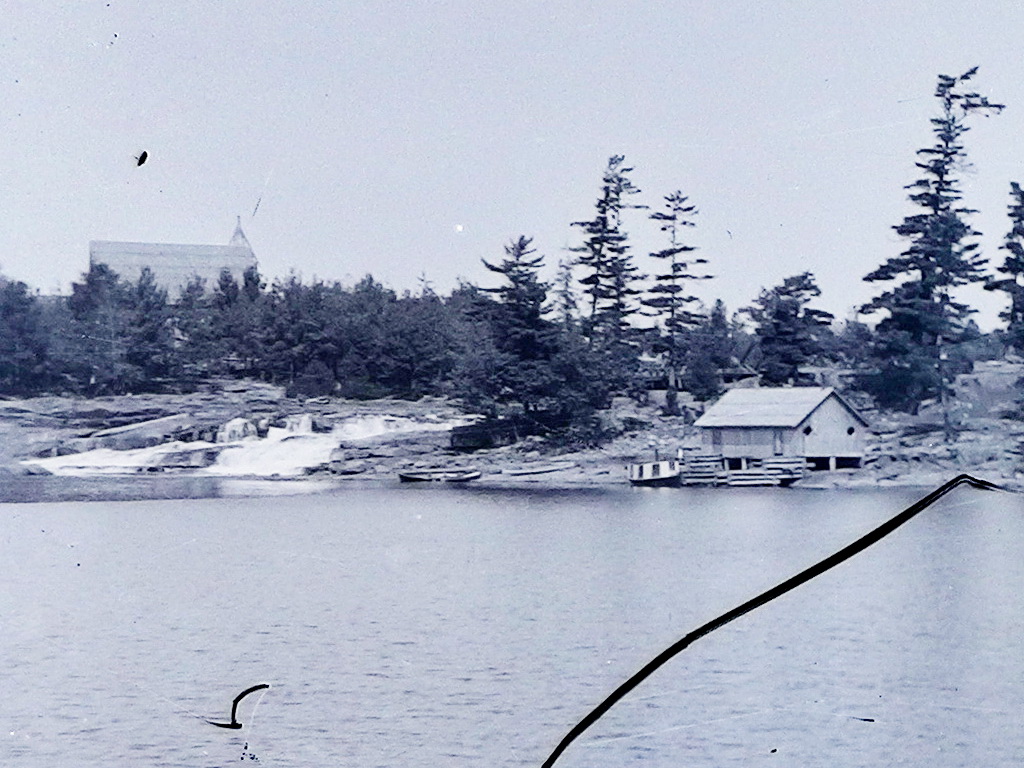
The fact is, the proponent’s current “Alternative 1A” proposal would be much more dangerous as the fast and turbulent water exiting the proposed generating station would be 250′ closer to the in-water recreational area at the base of the north falls.

And there would be two aspects of this which would make this water even more dangerous:

  1. Faster water.
    • The speed of the jet of water exiting the propsed station would depend on how much water would be going through the station.
    • The proponent would run as much water through their proposed generating station as they could, so more flow available from Lake Muskoka would result in more water through the station (up to its capacity).
    • Analysing the historical flow data for the Moon River shows that the water flow available is quite variable, but the summary is that, depending on the year,  the station would have been run at its maximum capacity every month of the year, even during many days of July and August – an average of 21 days each summer – when one normally thinks of there being low flow. Rain can happen at any time, and this would result in the plant running at full capacity.

  2. When the proposed station’s operation would be cycled.
    • As people would get a false sense of safety when the station was stopped, even though the remotely-controlled station could – and would – start at any time, since it all depends on the weather.
    • Analysing the last 44 years of water flow data shows that on average, the proposed station would have used the dangerous cycling operation for more than of all summer days (from May 1 to Labour Day).

In summary, the dangerous flow from the proposed station would not just be during spring runoff, or only for a few days every summer. During the summer months, the variable and treacherously turbulent water would occur often enough that it would always be a “clear and present danger” that could and would happen at any time, because:

  • The station would be remotely-controlled with nobody present (video cameras would only be as good as the lighting and weather conditions – and the remote operator’s attentiveness – permit), not good enough for safeguarding life given how many people will be both up- and down-stream of this location, day and night, and in all seasons of the year.
  • It all depends on the weather, so there would not be any way for those nearby to know when the water would be safe.

Below is the analysis of the Moon River flow, both for when the station would be operated at full capacity, and when its operation would be cycled, as both would increase the danger to the public just trying to enjoy themselves in the water, as people have been at the base of the north falls for over 100 years.


Detail – Running at Full Capacity

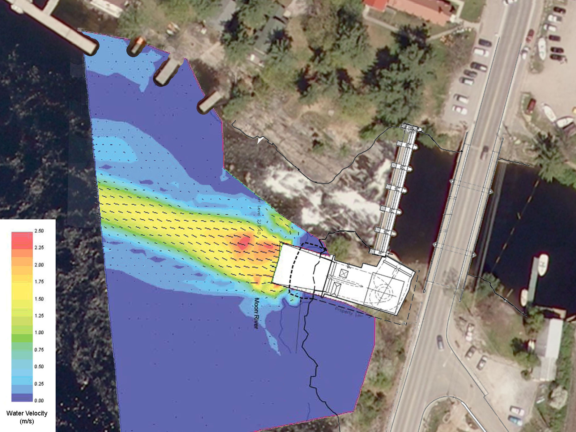
The proponent reported that the water velocity shown in the image below was for a flow through their proposed station of 98 m³/s – its maximum capacity.

So a good question is; how often and at what times of the year would the water flow at such a high rate.

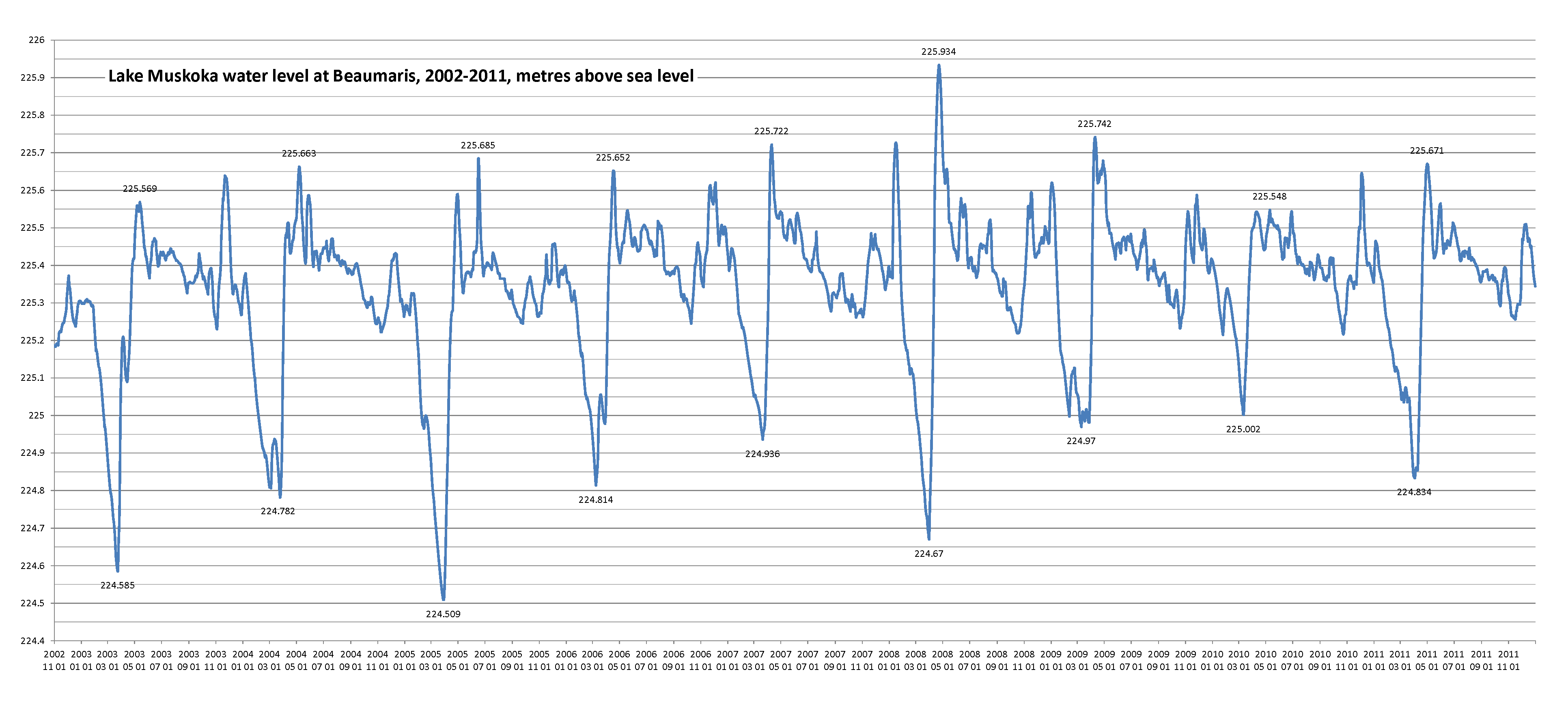
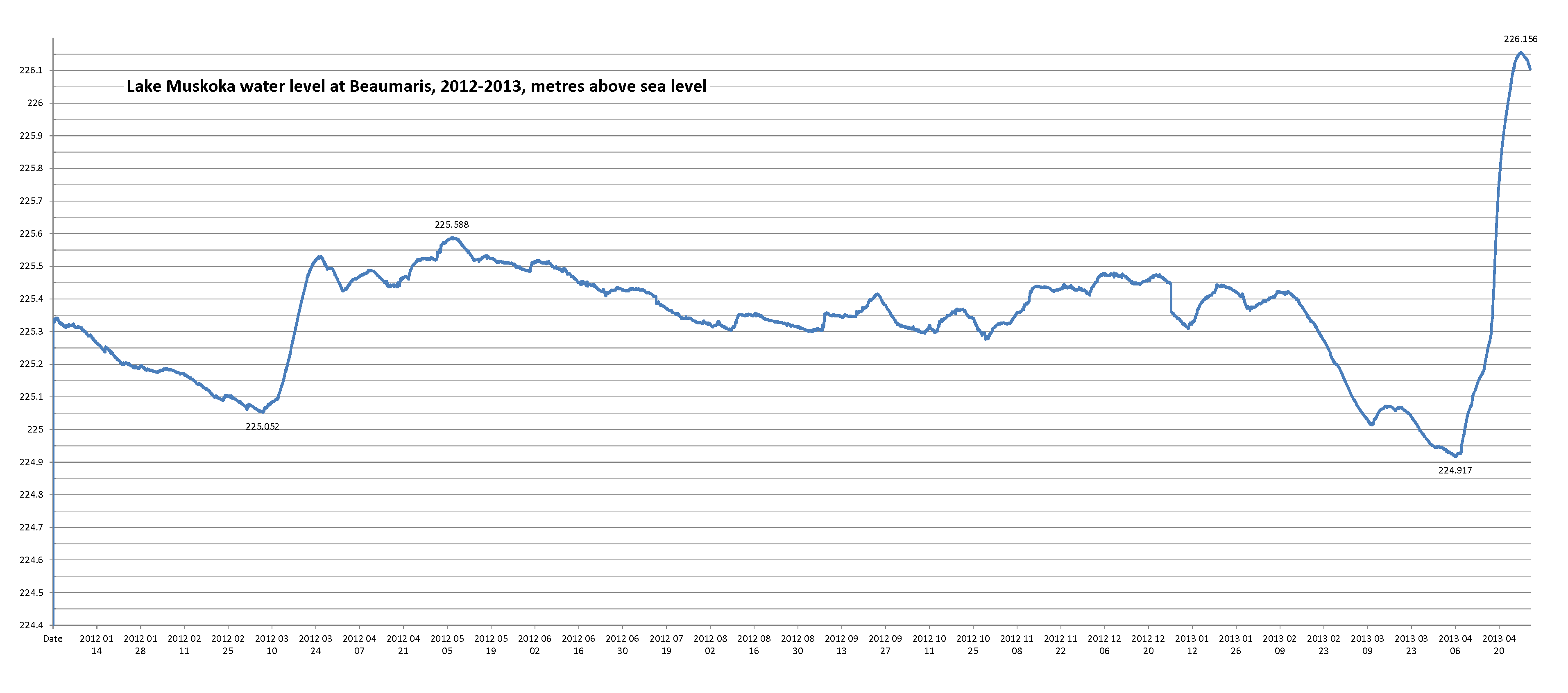
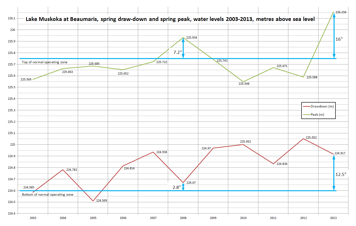
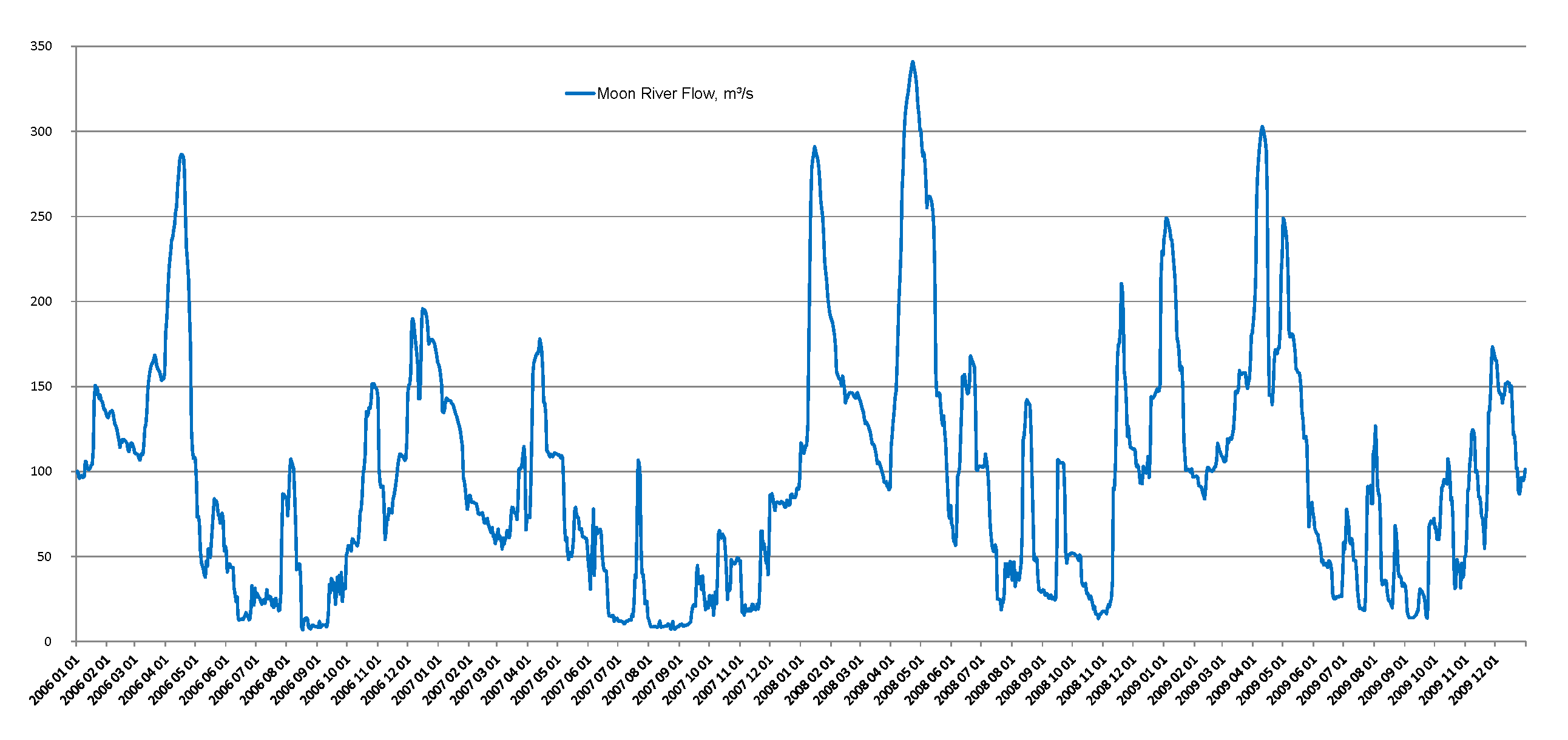
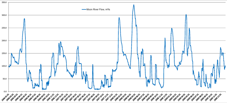
River flow data is available from Environment Canada, and for the Moon River, data is currently available from 1965 through 2009. This data can be graphed. For example, the graph below shows the day-by-day flow in the Moon River for the four years 2006 through 2009. The vertical axis units are cubic metres per second (m³/s), some examples of these units are that:

  • Both Ontario Power Generation’s Ragged Rapids generating station and the proposed station at Bala would have a maximum capacity of about 95 m³/s.
  • The Burgess Creek generating station has a capacity of 4 m³/s.
  • The proponent is proposing that the remaining flow over the Bala north and south falls would be 1 m³/s each, for most of the year.

The graph below shows the Moon River flow ranges from a minimum of as little as 10 m³/s each August to early September, to a maximum each spring (click on the graph for a higher-resolution view). As shown in the graph, the spring peak flow is typically 250 to 300 m³/s, but both the timing and the peak flow varies. For example, the peak flow during these four years was 340 m³/s on April 23, 2008. In fact, in 2008 there were two peaks, with a peak of 290 m³/s very early, on January 15, 2008. And in 2009 there were three or four peaks, with an early peak of 250 m³/s on January 4, 2009 and a late peak also of 250 m³/s on May 1, 2009 – these in addition to perhaps the “expected” spring peak which was on April 10, 2009 of 303 m³/s.

To better understand how the differing Moon River flows would affect public safety, some analysis is needed.

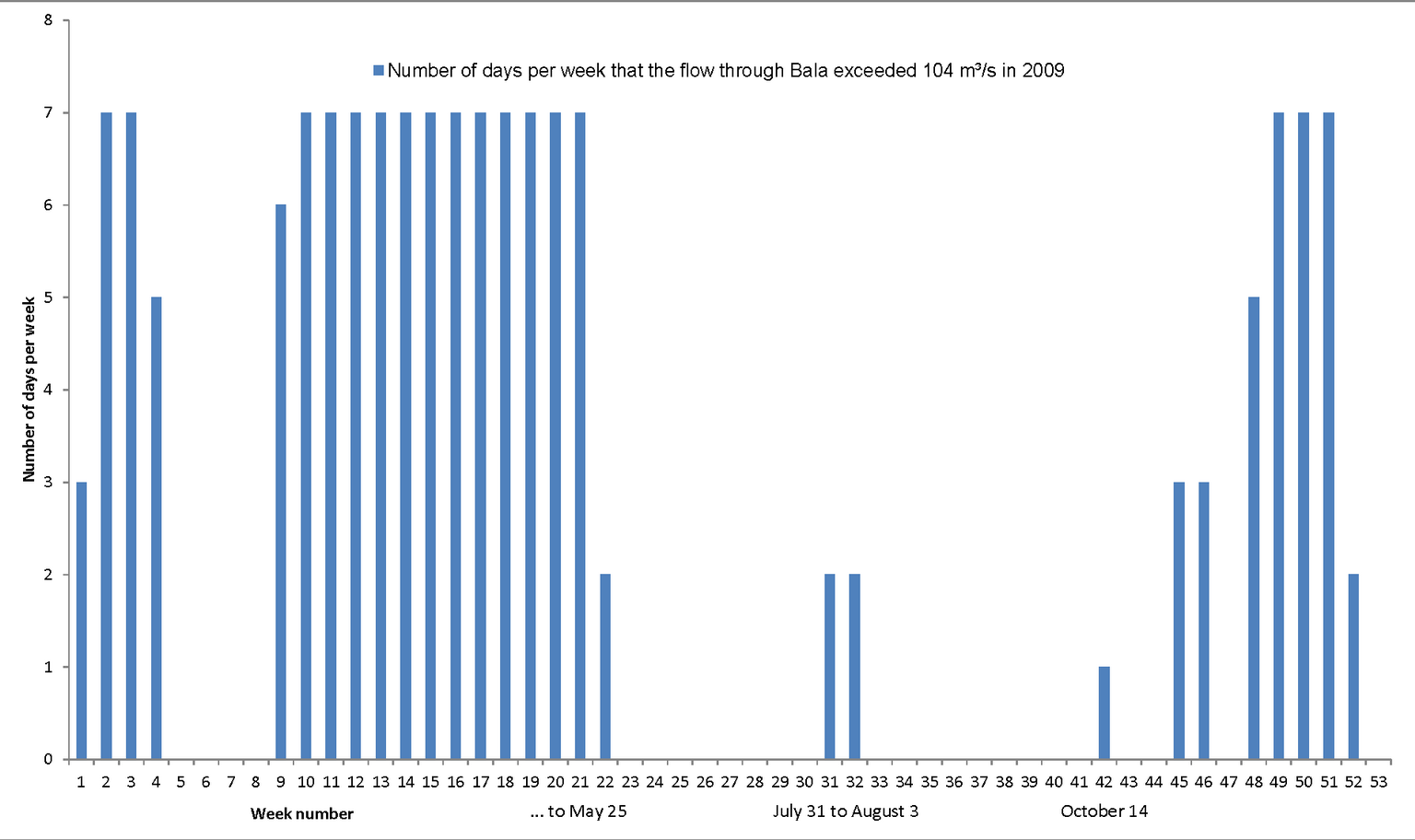
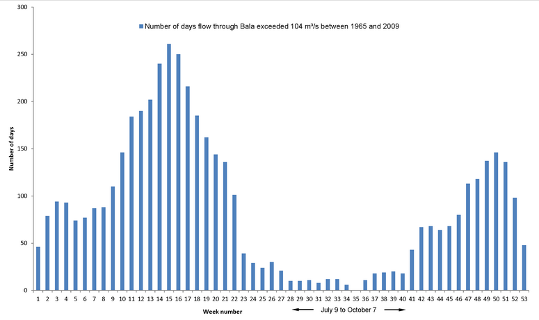
For example, for a flow of 98 m³/s through the proposed generating station, the total flow down the Moon River would be 104 m³/s (since there would also be a piddly 1 m³/s of flow over each of the Bala north and south falls and 4 m³/s of flow through the Burgess generating station on the Mill Stream). The histogram below shows that the proposed generating station would most often run at full capacity in the spring, as one would expect. But the histogram below also shows that in the 44 years of data available, the proposed station would have operated at full capacity at least 10 times during most every week of the summer as well. That it, the treacherously dangerous water from the proposed generating station could and would flow just metres from the in-water recreational area at the base of the north falls at any time of the year, even during the summer.

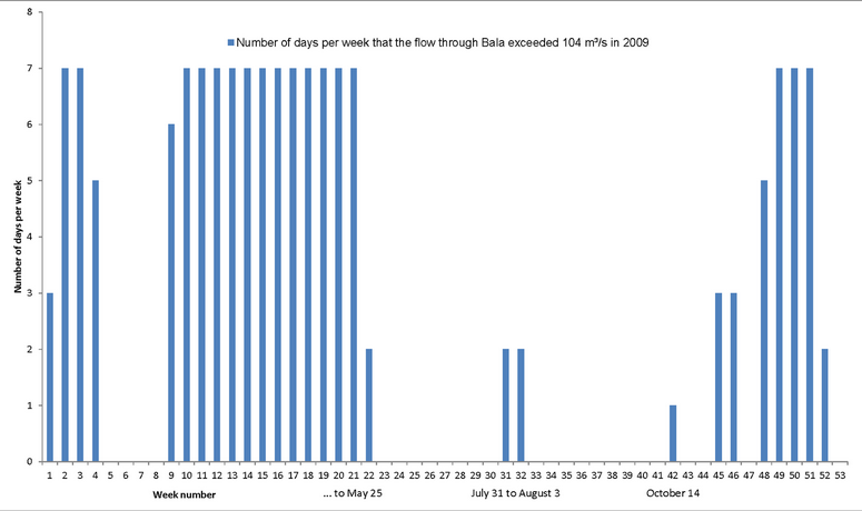
Let’s look at some particular years – below are histograms for each of the most recent three years for which complete data is available. The histograms show how many times of each week of the year the proposed generating station would have been operating at full capacity, producing a jet of fast and turbulent water just metres away from the base of the north falls.

The histogram below is for 2009 and shows the station would have been running at full capacity:

  • Until May 25.
  • For the four days, from July 31 to August 3.
  • On October 14.

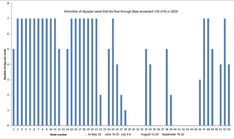
For 2008, as shown below, the proposed station would have run at full capacity:

  • To May 26.
  • From June 10 to June 25, and again from July 4 to 6.
  • From August 12 to 20.
  • From September 16 to 22.

Finally, for 2007, the station would have run at full capacity:

  • To May 6.
  • From July 21 to 22.

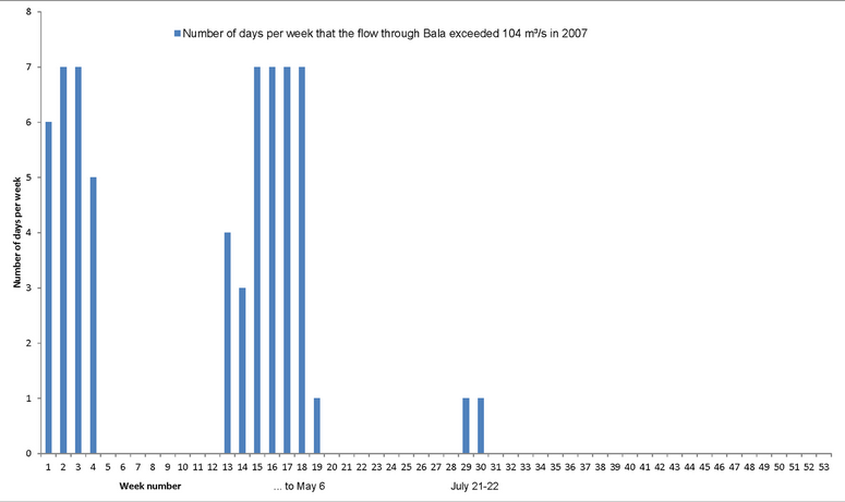
So, the point is, the station would be running at full capacity many times during the in-water recreation times of the year, we just wouldn’t know when or for how long.

Detail – Cycling Operation

But that’s not all, it gets worse. During the summer, the proposed station would frequently begin the day stopped and quiet, resulting in people ignoring any warning signs and playing in the water at the base of the north falls, as people have for over 100 years. But due to the proposed station’s cycling operation, for about of summer days, it would begin operating at about noon.

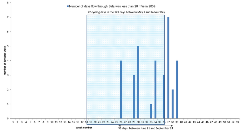
The Ontario Power Generation station at Ragged Rapids downstream on the Musquash River needs a flow of at least 26 m³/s to operate, and when there would be less than this (which occurs mostly in the summer), they would require the proposed generating station at Bala to cycle off until there is enough water built-up in Lake Muskoka so they can allow through at least 26 m³/s to run the Ragged Rapids station. This flow would likely begin at about noon each day, as that is when the peak demand for power occurs. So people may be playing at the base of the north falls, when the proposed – and remotely-operated – generating station would begin operation each summer day. So the question is, how often would such cycling operation begin during the period from May 1 to Labour Day, as that is when it is most likely people would be in the water nearby.

Firstly, the histogram below shows how many times per week the flow in the Moon River has been below 26 m³/s between 1965 and 2009. As expected, this is mostly during the later summer, but it ranged from early April to mid-December. Some statistics are:

  • During these 44 years, cycling would have been required an average of 75 times per year, with 61% of the cycling days during the peak in-water recreation time from May 1 to Labour Day.
  • Cycling would have occured 2,029 times out of the 5,683 days between May 1 and Labour Day, so on average, cycling would have been required for 36% of these summer days, which would have been 46 days each summer (this may be reduced slightly, as cycling operation in May might not be started if the Walleye have not yet had their two weeks to spawn).

Looking at recent years in particular, the histogram below shows that for 2009, the proposed station would have operated in cycling mode on 33 days, between June 21 and September 24, and there would have been 22 days between May 1 and Labour Day with cycling operation, which would be 17% of summer days.

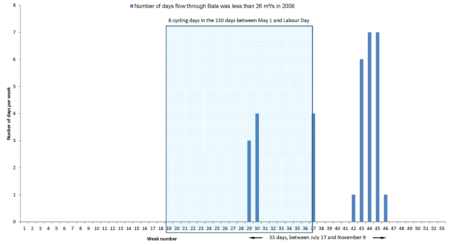
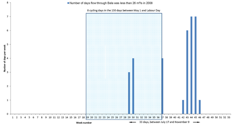
For 2008, as shown below, cycling mode would again have been needed on 33 days in total, but only 8 of these days would have been between May 1 and Labour Day.

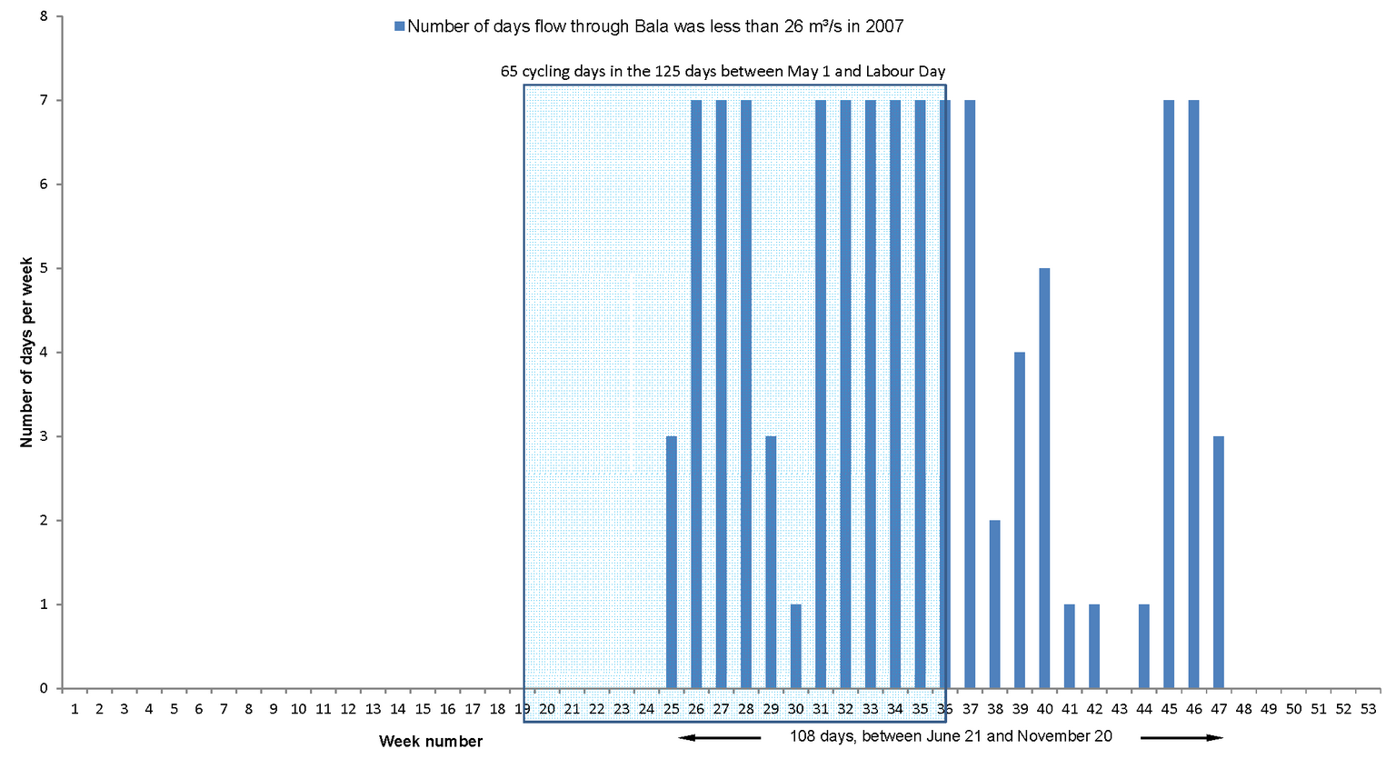
For 2007, cycling mode would have been needed on 108 days, spanning June 21 to November 20, and there would have been 65 days between May 1 and Labour Day with cycling operation. That is, there would have been cycling operation on more than half of the days between May 1 and Labour Day.

Feb 102013
 

The image below (higher-resolution image here) uses colour-coding to show the speed of the water which would exit the proposed hydro-electric generating station in Bala. This colour-coding is:

  • The image provided by the proponent in their environmental screening report Addendum (which is the last image in their appendices, it is an 8 Mbyte file)
  • Here superimposed on an aerial photograph to show where this fast water would be relative to the base of the north falls.

So instead of this fast water entering the Moon River 250′ away through the south channel, the fast water would be just metres away from the base of the north falls where for over 100 years, families have splashed and played in the water. And during much of the summer, the proponent would be required to cycle the generating station off and on every day, so one would never know if the station is running, or not, or when the fast water will start.

And this fast water would have whirlpools, undercurrents and everything else that would drown and throw people out to the middle of the Moon River, making attempts to assist or rescue them even more difficult and dangerous.

This is insanity. This proposed generating station would be a fatal accident waiting to happen. The Ministry of the Environment says the proposed project can go ahead because there’s already a tiny “No Swimming” icon (along with one indicating “No Fishing”, what’s that about) way up on the red sign on the north dam so people shouldn’t be in the water anyways. Oh, and there’s a “No Boating” icon and a “Don’t play on the beach” icon too (really there is, click here to see a close-up), does that mean nobody can use a boat or touch the shoreline either, how far does one have to be to ignore this sign, the icons are already unreadable at the base of the north falls.

This is risk to families and in-water recreation, risk to the area’s tourism, risk to the proponent, and risk to their investors.

Who is going to have the good sense to stop this.

Feb 072013
 

For 125 years, National Geographic has travelled the world to visit and understand the most amazing places.

They have just published a book entitled 100 Places That Can Change Your Child’s Life”. The author, Keith Bellows, writes in the forward that he wrote the book for his children; “I wrote this book for them. Because they’ll inherit the world. And I want them to understand it. To know it. To experience it.”  Included in the book are Antarctica, Tasmania, and China’s Great Wall. And Galápagos, Machu Picchu, the Hawaiian Volcanoes, Loch Ness, Athens, Tuscany, Paris, and Venice.

And Muskoka. Yes, out of all the “competition” in the entire world, Muskoka is one of the 100 Places That Can Change Your Child’s Life.

In fact, this is the third time in three years that National Geographic has recognized that Muskoka is world-class special (see here).

Here’s what the book says about Muskoka (which is the only place in all of Ontario selected):

  • The section begins “If you’re looking for an unplugged place that’s a world away from powerhouse Toronto … head two hours north … to Muskoka”. And it continues “Families have gathered here for generations to revel in true wilderness that has somehow resisted the blandishments of modern times.” We’d like to point out that:
    • People don’t come to Muskoka to look at the side of a 100′-long reinforced concrete building beside dry rocks that used to be the Bala falls – yet this is what the proponent plans.
    • People don’t come to Muskoka to stand on a concrete look-out, beside a huge steel gate hoist mechanism, and surrounded by an architectural fence, to read an interpretive plaque explaining how beautiful it used to be – yet this is what the proponent offers.

  • For Muskoka, the book mentions the waterfalls, the scenery, and the “Loons and Lakes”. It continues “Muskoka is a throwback to an earlier time when families just hung out with no agenda and didn’t rely on man-made amusements to distract them or their children.” That is, we need to protect some places from development, and Bala is one of those places.

The back cover says the book “… sends you and your children globetrotting for life-changing experiences that will expand their horizons and shape their perspectives.”

The proposed hydro-electric generating station at the Bala Falls would ruin all this for Bala.

Save the Bala Falls. Save the world. For our children. Stop the proposed generating station at the Bala Falls.