Summary
As shown below, the Ministry of Natural Resources has a poor record of anticipating peak flow events. For example, in 2013 they could have reduced the water level of Lake Muskoka by an additional 12.5″, and this would have reduced the flooding of Lake Muskoka and the Moon River.
This is a concern as the proponent has asked the MNR to approve the installation of a cofferdam which would obstruct most of the north channel during the proposed construction. As we have shown here, high flows occur throughout the year, and this cofferdam could flooding of Lake Muskoka and damage the highway bridge over the north channel.
The MNR should therefore not provide location approval for the proposed project as the current design would risk damage to; private property, public infrastructure, and the local businesses and economy.
Detail
As we’ve seen, the flooding of Lake Muskoka, the Moon River and other waterbodies in the spring of 2013 was the worst in memory. The Ministry of Natural Resources has responsibility for managing water levels for these watersheds, and part of this work is to reduce the water level in Lake Muskoka (called “draw-down”) in advance of spring to accomodate the high flows expected.
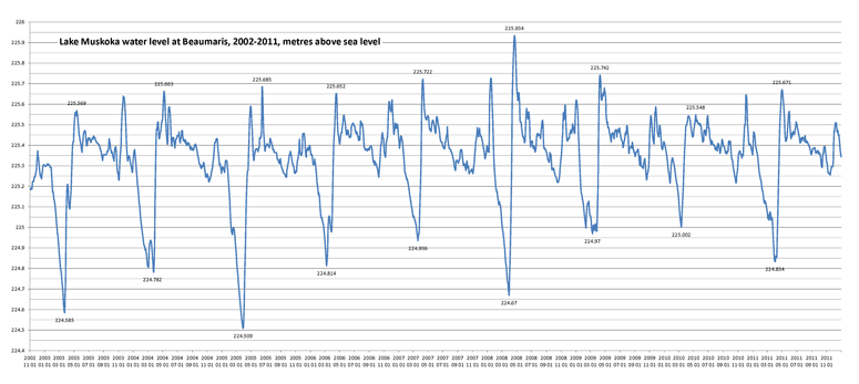
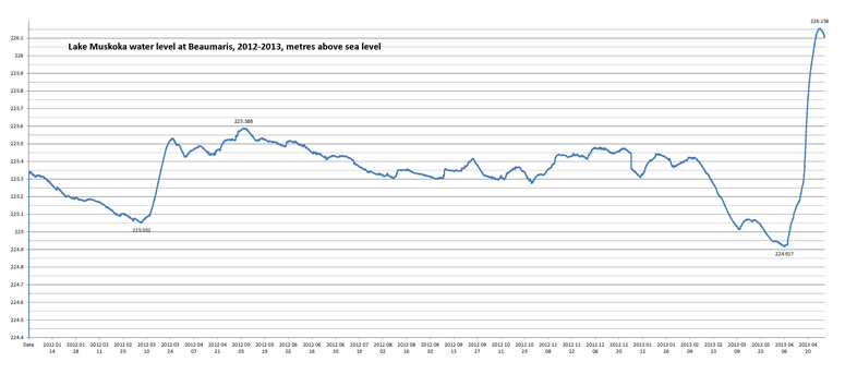
The Water Survey of Canada program collects and makes available water flow and level information. Since 2002 they have had a station recording the water level of Lake Muskoka at Beaumaris, and the graphs below (click on them for a larger view) show the water levels for 2002 through 2011, and for 2012 to 2013. Also shown on these graphs are the actual maximum draw-down in the spring, and the subsequent peak water level for each year, all given as metres above sea level (MASL).
As can be seen, the water levels are reduced by different amounts each spring. Staff at the MNR determine this draw-down according to many factors:
- The amount of snowfall which has yet to melt.
- How rapidly this snow is expected to melt.
- How frozen the ground is, as this determines how rapidly the water will end up in lakes and rivers.
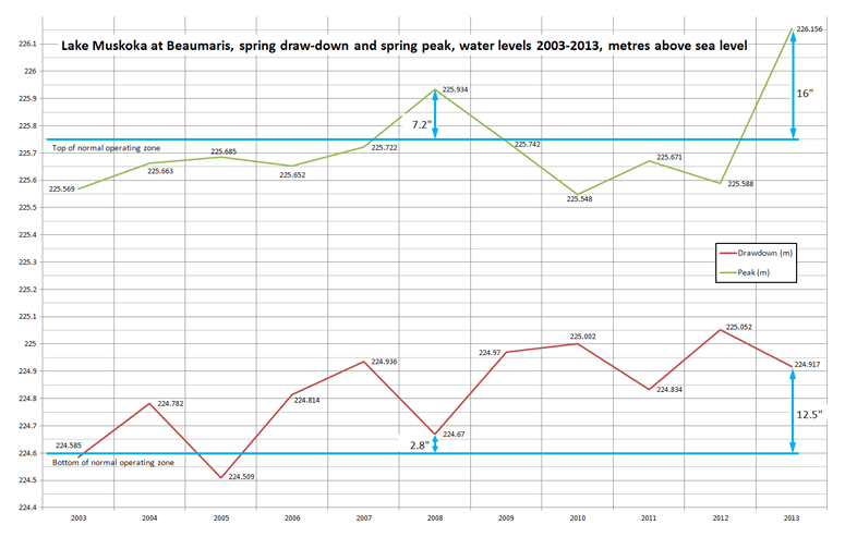
There are several water level limits established by the Muskoka River Water Management Plan. For example, page 12-106 defines the Normal Operating Zone for Lake Muskoka to be from 224.6 MASL to 225.75 MASL.
In 2013 the water level of Lake Muskoka peaked at 226.156 MASL, which is 16″ above the upper limit of the Normal Operating Zone.
The graph below shows the actual maximum draw-down and subsequent peak water levels for Lake Muskoka each spring for the past 11 years. The Normal Operating Zone is between the horizontal blue lines.
As shown, the MNR does draw-down water levels by different amounts each year. For example, in 2008 the water was drawn-down more than most years, however spring flooding still occurred. What this graph shows us is that the water could have been drawn down by an additional 2.8″, which would have reduced the subsequent flooding, which was 7.2″ above the Normal Operating Zone.
For 2013, the MNR could have drawn-down Lake Muskoka by 12.5″ more than they did, and this would have reduced the subsequent flooding, which was 16″ above the Normal Operating Zone.
Summary
As shown above, the MNR has a poor record of anticipating high-flow events for Lake Muskoka. And as shown here, the construction of the proposed hydro-electric generating station at the Bala falls would require obstructing most of the north channel during times when high-flow events have occurred in the recent past. The MNR should therefore not provide location approval for the proposed project as it would risk damage to private property, public infrastructure, and the local businesses and economy.


We agree that the MNR failed significantly in preventing the flooding in Muskoka this spring.There is no way a hydro plant should be allowed to be built in Bala unless the taxpayers can sue the government for the cost of any flooding and loss of income!