As we have noted over the years, other than during the few weeks of spring freshet, the proponent would divert 94% of the water through their proposed generating station, leaving only a trickle of 6% to go over the Bala falls.
A few months ago the proponent released an updated Scenic Flow Plan which would allow a slightly increased trickle on a few additional weekends. The graphs below illustrate the proponent’s current plan.
For these graphs, we’ve used the actual 2012 daily average water flow data through Bala, from Environment Canada’s Water Office. While the Mill Stream generating station can pass up to 4 m³/s (cubic metres of water per second) of flow, it isn’t known when or if this would be operating, so for simplicity we’ve assumed there would be no flow through the Mill Stream generating station.
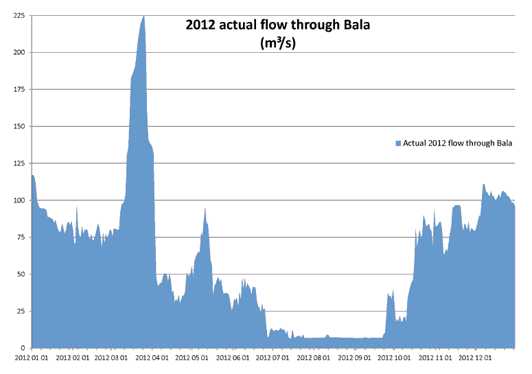
The blue area in the graph below (click on the graphs for a larger view) shows the actual flow through Bala throughout the year. We can see that in 2012 the highest flow was on March 26, when there was 225 m³/s of water flowing through Bala. As expected, the minimum flow was in the summer, with a flow of about 7 m³/s from mid-July to late September. The Water Office does not record the flow separately for the Bala north and south falls, though generally, the Ministry of Natural Resources and Forestry sets the stop-logs so most of the flow is over the south falls.
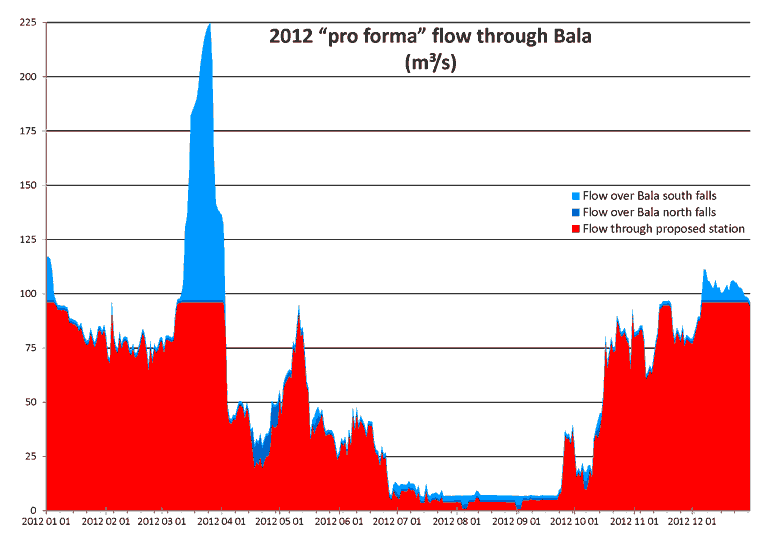
The “pro forma” graph below shows the same total flow through Bala (for example, still a peak flow of 225 m³/s on March 26, 2012, and a minimum flow of 7 m³/s from mid-July to late September), but this shows that except for the trickle of flows allowed over the Bala north falls (in dark blue) and Bala south falls (in light blue), most of the flow would be through the proposed generating station (in red), up to the proposed station’s capacity of 96 m³/s.
As shown, in 2012 the only noticable flow would have been over the Bala south falls, and this only for three weeks in the spring, when the proposed station couldn’t have handled all the flow. The south falls would also have some flow for a few weeks in the winter. Throughout the entire year, the north falls would have continued to be the same trickle as throughout the rest of the year (with a slightly increased trickle for two weeks in April for Walleye spawning).
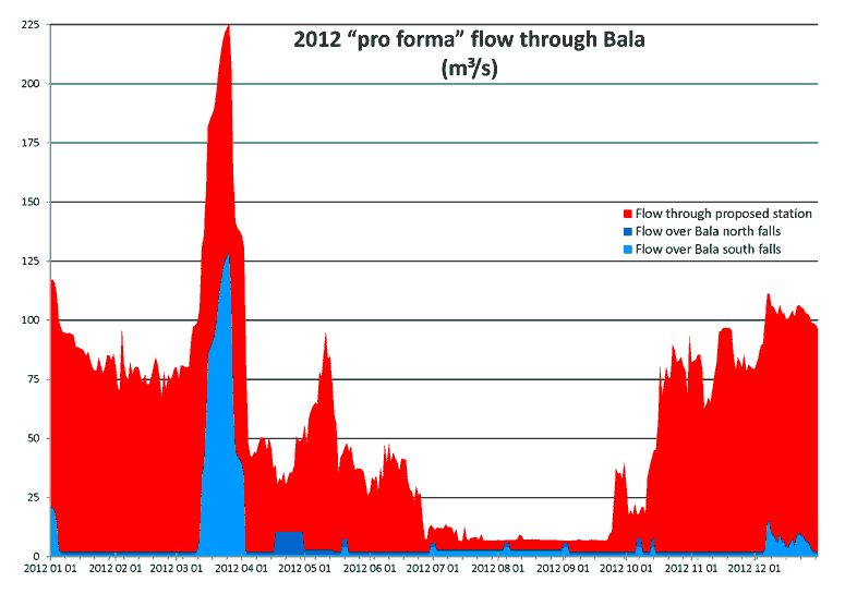
The graph below is the same data as above, but puts the flows over the Bala north and south falls at the bottom of the graph. This better shows:
- The flow would be a miniscule trickle of 1 m³/s over each of the Bala north and south falls throughout most of the year.
- During the summer, there would instead be an increased trickle of 2 m³/s over the Bala south falls.
- There would be an increased flow for two weeks in April for the Walleye spawning, and an increased trickle for two weeks after that for egg incubation.
- For a few weekends after that, there would be an increased trickle.
But overall, as the red area shows, only 6% would go over the falls.
Other falls where tourism is important require much more flow over the falls. For example, by international agreement, 50% of the flow of the Niagara River must go over the Niagara Falls during tourism times and seasons.
The proponent claims their plan for Bala would allow the same flow throughout the year as flows during the summer, but as shown here, this is a lie. The Bala proponent is just being greedy.