Summary
In 2005, when the Ministry of Natural Resources made the opportunity available to build a hydro-electric generating station at the Bala falls, a requirement of the MNR’s Request for Proposals was that proponent’s “demonstrate consideration of the extensive aesthetic, recreational, social and economic (i.e. tourism) values in the area”. As part of the competitive selection process, the proponent’s 2005 proposal showed compliance with this by stating and showing that the roof of their building would be below the level Muskoka Road 169. They continued to show this in 2007, and again in 2012. However, their current information shows that instead their proposed building would tower three storeys above Muskoka Road 169, blocking the view down the river.
What the proponent showed in the past
The proponent was awarded the opportunity to pursue construction of a hydro-electric generating station at the Bala falls through a competitive process, for which the proponent submitted a proposal in 2005 which included this rendering of its appearance (click on it for a larger view).
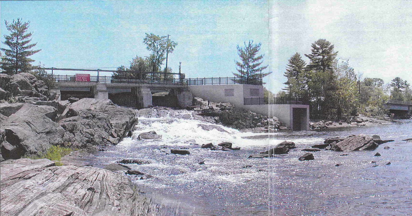 Proponent’s Option 1 rendering from their 2005 proposal
As you can see, the roof of their proposed building is shown to be level with the deck of the Bala north dam, and so it would be below the level of Muskoka Road 169. This description and rendering are from their 2005 proposal, selected pages are here. This 2005 proposal described what is now referred to as their Option 1, and as you can see at the added highlighting on the second of those selected pages, Option 1 was to be built solely on the Crown land directly south of the Bala north falls. The proponent provided further information on their Option 1 at the Public Information Centre they held at the Bala Community Centre on Wednesday, August 29, 2007. Note that on page 9 of the materials presented is a scale drawing, with dimensions, showing a vertical cross-section of the proposed building, from which we can see the following:
- The roof would be level with Muskoka Road 169 (even allowing for the internal overhead bridge crane and hoist).
- The intake stop-logs and tailrace gate and hoist mechanism would all be contained within the proposed building.
So the proponent’s plan to build solely on Crown land certainly appeared well-researched and credible.
In June 2012 the proponent released an Addendum to their 2009 Environmental Screening/Review report. This Addendum described the proponent’s current Alternative 1A proposal, and as detailed in Section 2.1 (that will take some time to download), Alternative 1A could also apparently be built solely on the Crown land. On pdf page 72 of the Addendum, the proponent provided a rendering of their Alternative 1A proposal, which is reproduced below (click on it for a larger view). They describe this rendering on pdf page 58: “The proposed Alternative 1A powerhouse is higher than the powerhouse needed for Alternative 2D [option 2] in order to house the vertical turbine. This turbine configuration is required to remain within the smaller site footprint.” As can be seen, this is indeed a few feet higher than the deck of the Bala north dam.
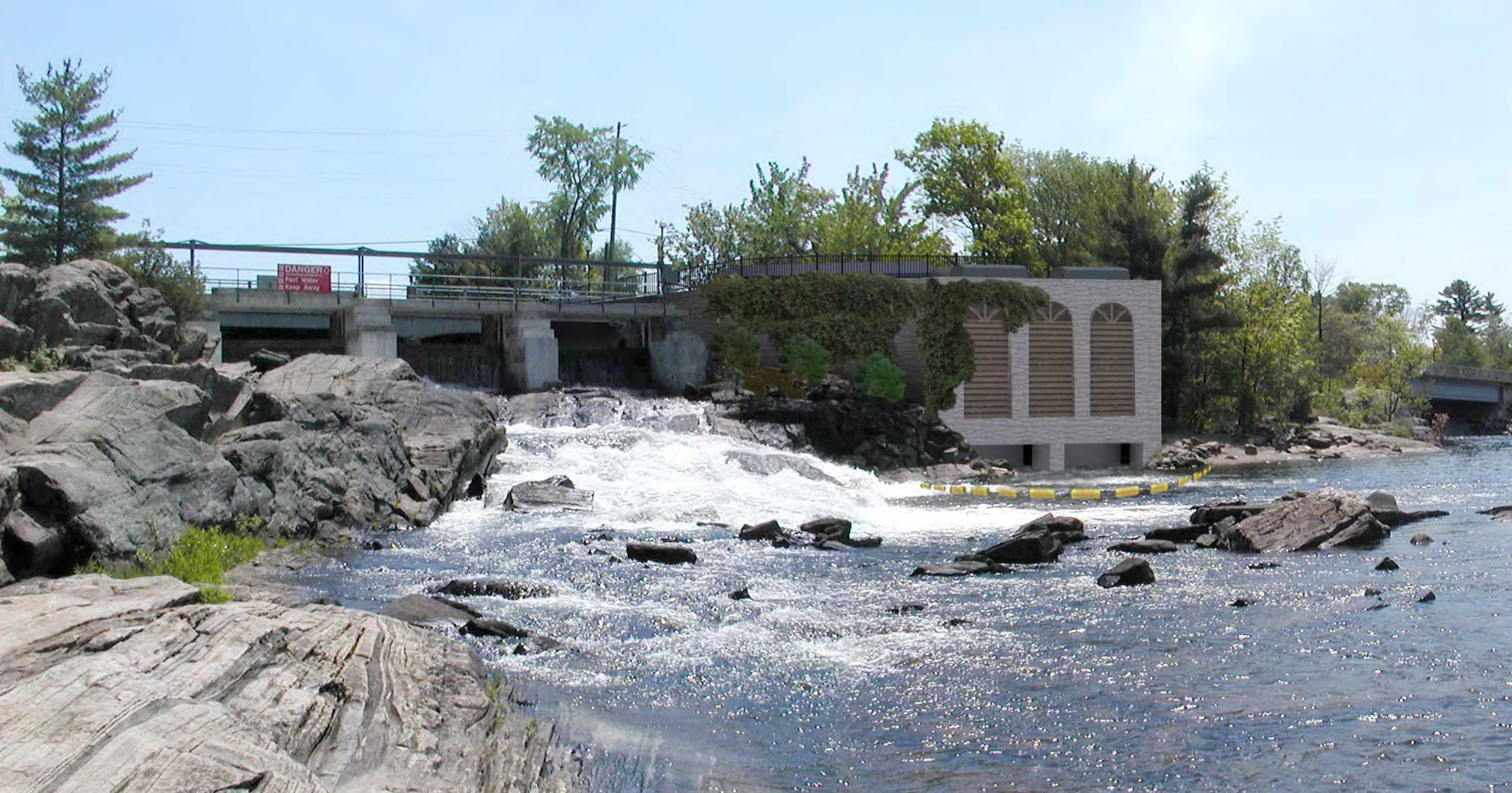 Proponent’s Alternative 1A rendering from their 2012 Addendum
On pdf page 29 of the Appendices to the Addendum, the proponent provides dimensions for their Alternative 1A proposal, as reproduced below. This shows the roof of the proposed building would be 30′ above the Moon River.
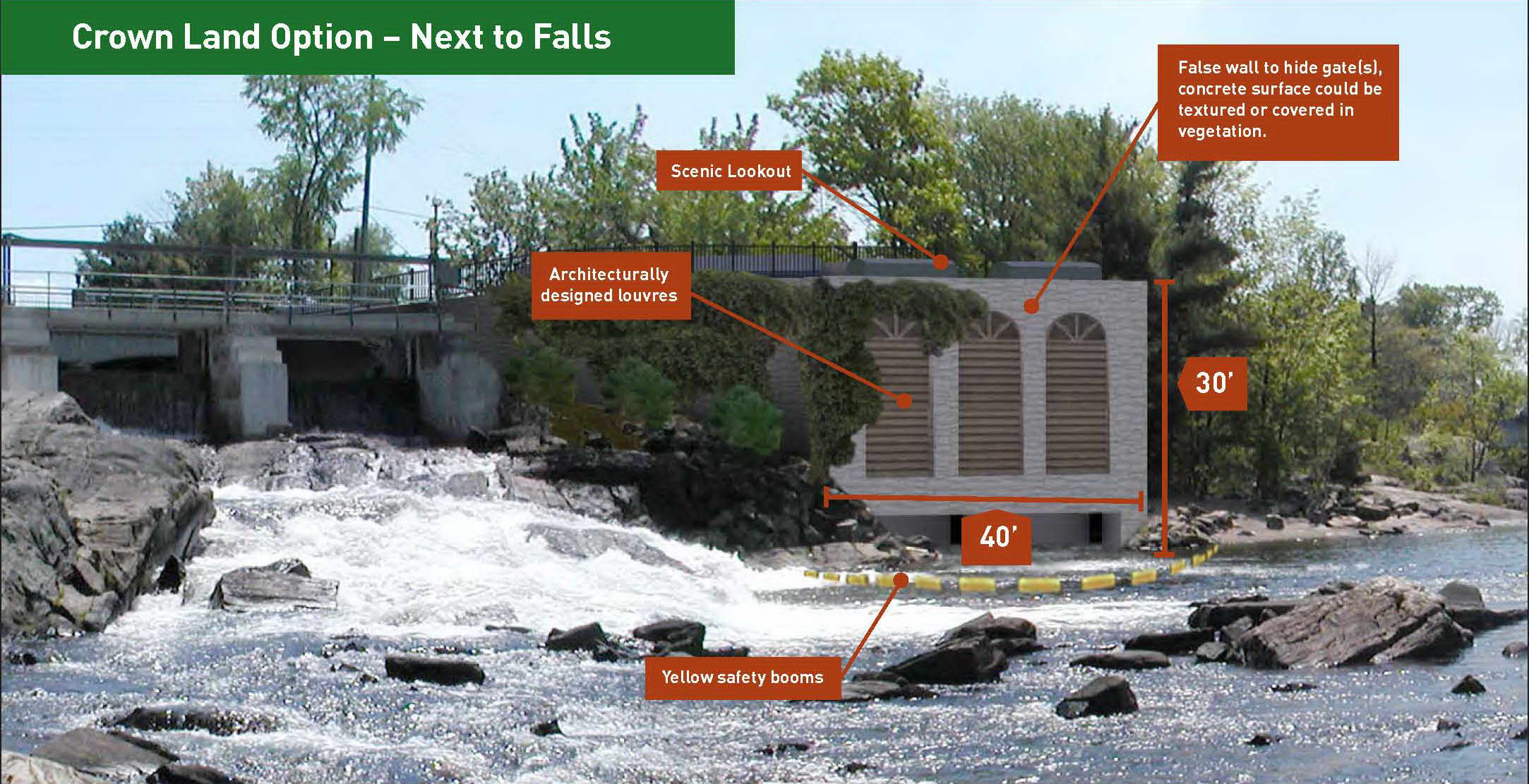 Proponent’s Alternative 1A rendering from their 2012 Addendum Appendix C
So, from 2005 to 2012 the proponent provided several dimensioned drawings showing the entire structure would not be higher than Muskoka Road 169, and would be about 30′ above the Moon River.
What the proponent is now claiming
In a presentation to the Township of Muskoka Lakes Committee of the Whole on December 16, 2014, the proponent showed some preliminary scale drawings of their proposed Alternative 1A building, two of these drawings are reproduced below, with added dimensions.
This drawing (click on it for a larger view) shows a vertical cross-section, looking south. On the left is Muskoka Road 169 and on the right is the Moon River:
- The red outline shows the technical equipment which would be required.
- The highest roof is what the proponent’s engineering design consultants suggested the building outline be.
- The peaked heavy black line below that is what the proponent’s architect Karl Stevens speculated a building outline could be.
- We have added the horizonal red line below that, as the proponent claims this would actually be the height of their proposed building, 6.2 m (20.3′) above Muskoka Road 169.
The blue lines are apparently sight lines of the person (highlighted with the green arrow) attempting to look through the building to see down the Moon River.
So the heights would be:
- The proposed building would be 6.2 m (20.3′) above Muskoka Road 169 (this is the about the height of a two-storey building) and 15 m (49′) above the Moon River (this is the height of a five-storey building).
- The tailrace gate hoist mechanism would be 10 m (32′) above the Moon River.
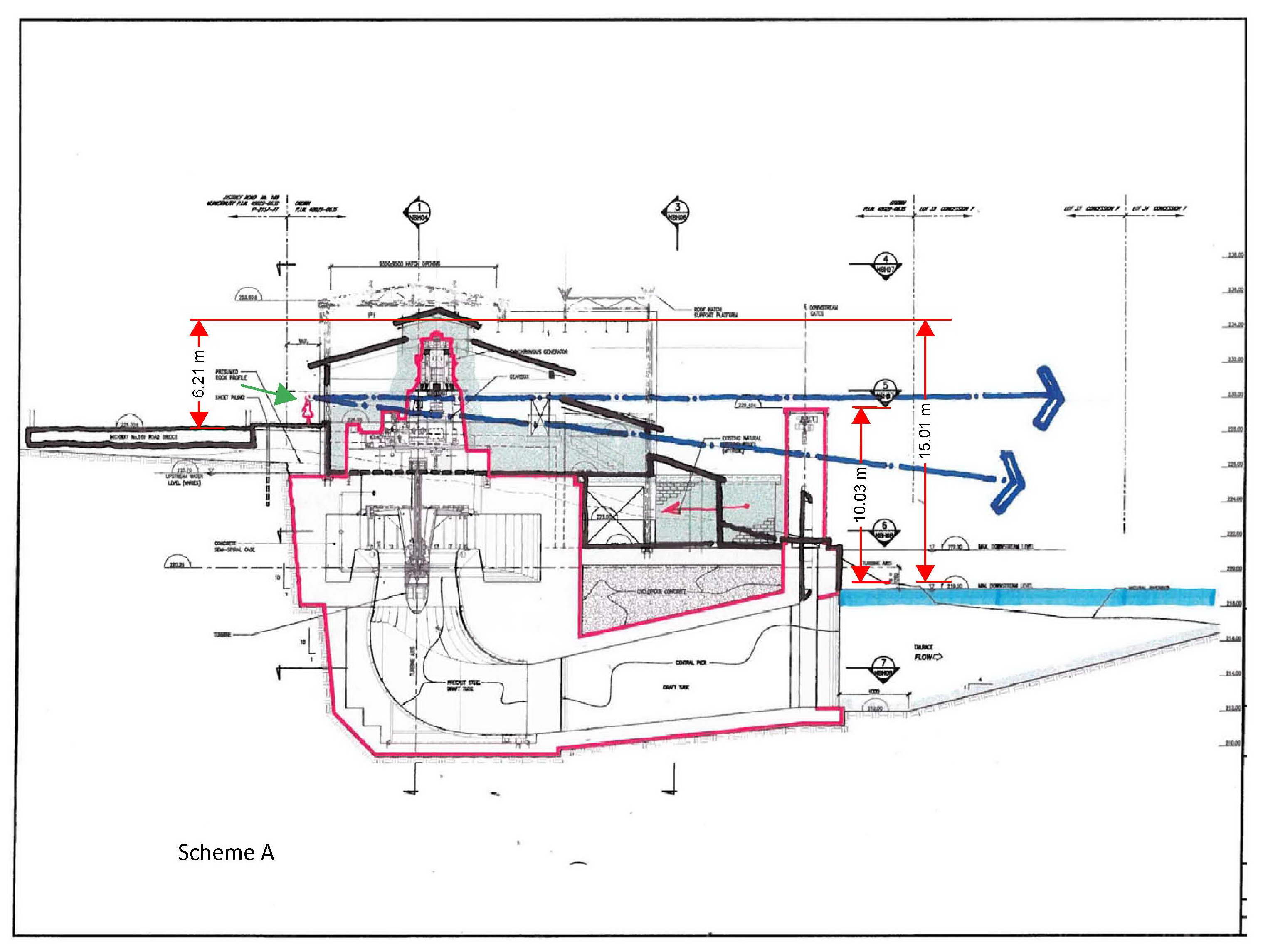 Proponent’s Alternative 1A north cross-section from their December 16, 2014 presentation to the Township of Muskoka Lakes, height dimensions added
The proponent also provided a vertical cross-section looking east. As shown below, the intake would be on the north side, which is to the left, and the driveway would be on the south side, to the right. Even if the height of the building could be reduced, the intake gate hoist mechanism would be 7.41 m (over 24′) above Muskoka Road 169.
 Proponent’s Alternative 1A west cross-section from their December 16, 2014 presentation to the Township of Muskoka Lakes, height dimension added
Conclusion
We see that while for years the proponent provided statements, drawings, and renderings showing they would honour their 2005 proposal commitment that the roof of their building would not be above the level of Muskoka Road 169, their more recent information shows that it would tower over 20′ (about two storeys) above Muskoka Road 169, blocking the view down the river.
The proposed building would also be 100′ long, completely ruining the view from Margaret Burgess Park, and there would be no landscaping on the site, as the entire 70′ x 100′ Crown land site would be concrete.
The proponent choosing to provide such incorrect information as part of the competitive process through which the proponent was selected justifies the Ministry of Natural Resources to cancel this proposed project, without risk of having to pay whatever costs the proponent may incurred.
Having attended several presentations by the company proposing this dam…and never having anyone really willing to answer the townspeople’s questions, it does not surprise…but does dismay me….that their current proposal goes against previous renderings (28 ft. higher!?!). I agree this is grounds for cancelling of this by the MNR, without penalty.