Aug 272014
 

From this letter and this media advisory, we have learned that the Wahta Mohawks were not properly informed or consulted on the proposed obstruction of the Bala Portage.

They will be conducting a "Portage-In" at the Bala falls tomorrow – this Thursday August 28, 2014at 11:00 am, to show their concern. As all the original members of the Wahta Mohawks used the Bala Portage when they first arrived from Oka Quebec in 1881, this is an important part of their heritage.

They will apparently be using the Bala Portage, CTV News and other media will be there, so we should be there too.

Come out to show that the general community supports the Wahta Mohawk’s concerns:

  • If you would like to be part of the flotilla, be at the Town Docks on the Moon River at 10:30 am this Thursday August 28, 2014 with your canoe or kayak (and PFD and marine safety kit).
  • Otherwise, be at the District property just south of the Bala north falls at 11:00 am.

This event is about the Bala Portage, so no red T-shirts and no signs. We’re there to support the Wahta and the Bala Portage.

Aug 272014
 

In 1837, the government of Upper Canada selected explorer and cartographer David Thompson to survey a river route between Lake Huron and Ottawa to facilitate trade and the transport of goods along a route far from the border with the United States (this was only 25 years after the war of 1812, governments didn’t move any faster back then). This route would be from the Muskoka River to the Madawaska River to the Ottawa River,and Thompson was to determine the feasibility of building any required locks to raise and lower boats so they could bypass rapids, waterfalls and other non-navigable sections of river. Thompson’s maps and journal therefore included great detail, including the length and slopes of rapids and the type of rock. His notes included details of the types of trees (for logging or construction), wildlife, the weather, suitability of the land for farming − and encounters with First Nations.

In 1994, as a commemoration of their centenary, the Muskoka Lakes Association published a magnificent hard-cover book entitled SummerTimes: In celebration of 100 years of the Muskoka Lakes Association. Local author and Thompson expert Séan Peake contributed a 14-page chapter which includes a transcription of Thompson’s journal for the 12 days he was on Lake Muskoka, Lake Joseph, and Lake Rosseau, beginning as he first sets out onto “Swamp Ground Lake” (as Lake Muskoka was then called). From the detailed distances and directions in Thompson’s journal, Peake was able to determine the current name for the locations of Thompson’s travels and observations on the lakes (these are provided in square brackets).

Some examples of Thompson’s encounters are:

  1. On August 14, 1837, Thompson has finished camping for the night at the Bala falls, he writes up his journal, notes that what is now the Bala south channel could be made into a lock, documents the direction, slopes and rises of what is now the Bala north falls, and at 9:32 am sets off from what is now Diver’s Point towards Lake Muskoka (more detail here). After it rains and having lunch, Thompson writes: “At 12:10 pm, set off and held on to 1:35 pm, when very heavy rain, with loud thunder came on and we had to keep under the shelter of a point of rock, and let it fall on us to 3:15 pm when we crossed N46E to an islet 500 yards and camped where the Indians have been [the south-eastern point of Charybdis Island].” That is, there was a First Nations camp on Charybdis Island (which is south of Mortimer’s Point).
     
  2. Still on Lake Muskoka, Thompson’s August 15, 1837 journal entry includes:
    • “Saw an Indian lodge and in hopes of getting information went to it about 1½ miles off, but no person, suppose they have gone to Lake Huron …”. That is, it was clear to Thompson that the Bala Portage, which he had just used the previous day, was used by the First Nations, who were living on Lake Muskoka.
    • “… At the Indian lodge, fine ground and hardwood and small patch of potatoes look well but the potatoes are yet very small.” That is, the First Nations lived and farmed on Lake Muskoka.
       
  3. His August 16, 1837 journal entry includes: “Held on and camped at the Indian lodge [at Eileen Gowan Island], bad campment, at 6:10 pm, the cat but no person. Many flies. Thank God we have had a very fine day and employed it well. The country appears as barren of berries as of everything else. Agriculture may do well here but nothing else will. The whole of the large islands on which we camp is mostly good land.” That is, the land is not very fertile, but there are First Nations living on Eileen Gowan Island, and they even have a cat.

In summary, it is clear the First Nations of the area lived on Lake Muskoka in 1837, and they created and used the Bala Portage.

Below is a page of Peake’s chapter in the SummerTimes book (click on it for a larger view). The book is now out of print, but used copies in excellent condition are available from Amazon.ca and other sources (ISBN 1-55046-081-1). It is most interesting to read.


Aug 122014
 

The Village of South River is about an hour’s drive north of Huntsville and is the developer and owner of the South River hydro-electric generating station, which began operation in 2011.

A very important difference between the South River generating station and that proposed in Bala is that the South River falls are somewhat inaccessible, few people know about or visit them, and therefore their loss has had little effect on the local economy.

The photographs below (click on them for a larger view) are of the same section of the South River falls (the rock at the top-centre is the same in each). At the left is the “before” photograph, and the right is after the generating station was in operation.

As we’ve said, people won’t come to see the dry rocks where the falls used to be.

The “before” photographs are from the book Waterfalls of Ontario by Mark Harris, who writes: “This series of small waterfalls offers some interesting exploring and close-up photograph. The river pours over a wide expanse of exposed bedrock, creating a hodge-podge of interesting little rapids, cascades and slides. At no place is the fall more than a few meters. At another spot, a giant submerged old wooden beam (possibly from some long-vanished mill building) forms the crest of an artificial low, wide waterfall. You can wander out on the bare polished bedrock and explore the site to a degree. Even more cascades can be found downstream of the road, but the land surrounding these is private, so you are able to enjoy them only from the bridge. If you walk another 200 meters north to a short driveway on the right, you will find a parking area overlooking the river just upstream from the falls.”

Below is another view before and after the South River generating station was in operation (note the MNR dam at the top-left in both).

Everyone involved with the project (MNR, developer …) is very happy with the South River project, and you can be sure this is just what the proponent would like to do in – Bala leave us high and dry.

Thanks to supporter Marilyn for these photographs.

Aug 112014
 

Visitors to Diver’s Point (the public land beside the Bala south dam) over the last few years will recall the memorial trees and plaques towards Bala Bay. These were installed with the permission of the Ministry of Natural Resources and by Bala’s Communities in Bloom committee as a result of their soliciting ideas and donations, and these beautified the area and honoured family members of long-time residents of the area.

In an apparent bizzarre fit of trying to be overly-helpful to the proponent, the MNR contracted to have all trace of this memorial removed, as shown in the “before” and “after” photographs below (click for a larger view).

The MNR’s actions are truly inept:

  • The trees were relocated in July, which is completely the wrong time for such deciduous trees. Given that the MNR is now officially called the Ministry of Natural Resources and Forestry one would expect they would know a thing or two about trees. And there is certainly no rush for this work, the proponent is not allowed to start any work until October 20, 2014 (if even then).
  • The MNR knew the trees were planted as part of a memorial, yet the family for whom three of the trees were planted were not informed that the trees were to be relocated, were not told (or asked for input to) which trees should be relocated where, and still have no information on where the trees or the memorial plaques are.
  • As anyone associated with a memorial knows, the location is a key part of a memorial. And moving a memorial would be wrenching, especially when done in such an insensitive manner. This would dishonour the memory of the loved ones.
  • The MNR knows the Communities in Bloom contact, and the Communities in Bloom contact knows the families, so there is no excuse for such insensitive action.
The plaques are now gone

This continues to show that the community cannot trust that the MNR can or will do anything right, and we must continue to ensure that the MNR hears from the community.

Aug 082014
 

In 2009 the proponent released their Environmental Screening Report for their Option 2 proposal. While this would have obstructed the Bala Portage at the Bala Bay end (beside Purk’s Place), as shown by the red line below, it would still have been possible to reach Bala Bay from Diver’s Point (click for a larger view).

The proponent’s current proposal was presented in their 2012 Addendum, and they referred to it as Alternative 1A. This proposal would completely obstruct the Bala Portage at the Moon River end, as shown by the red line below.

There are no acceptable alternate portage routes to reach the Moon River, as:

  1. Margaret Burgess Park would be fenced-off during construction, and apparently afterwards as well.
  2. Using the Township docks on the Moon River requires trespassing on private property. Also, this route is unacceptably dangerous as it would require:
    • Portaging along Portage Street, which has no shoulder and no sidewalks.
    • Walking along Muskoka Road 169 behind or beside parked cars.
    • Crossing Muskoka Road 169 just south of the curve in the road, so cars approaching from the north and portagers cannot see each other until they are too close.
  3. Portaging along River Street requires paddling on Burgess Creek under the Muskoka Road 169 bridge, where the water speed is too fast.

Additional detail is here.

The Bala Portage has always been south of the Bala north falls (detail here), and this continues to be the only acceptable portage through Bala.

Aug 012014
 

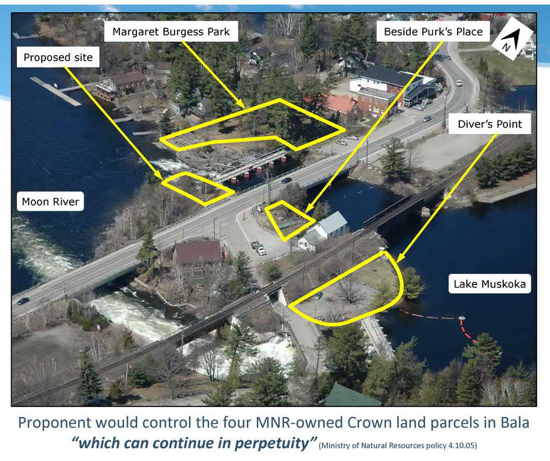
Margaret Burgess Park Would be Fenced-Off

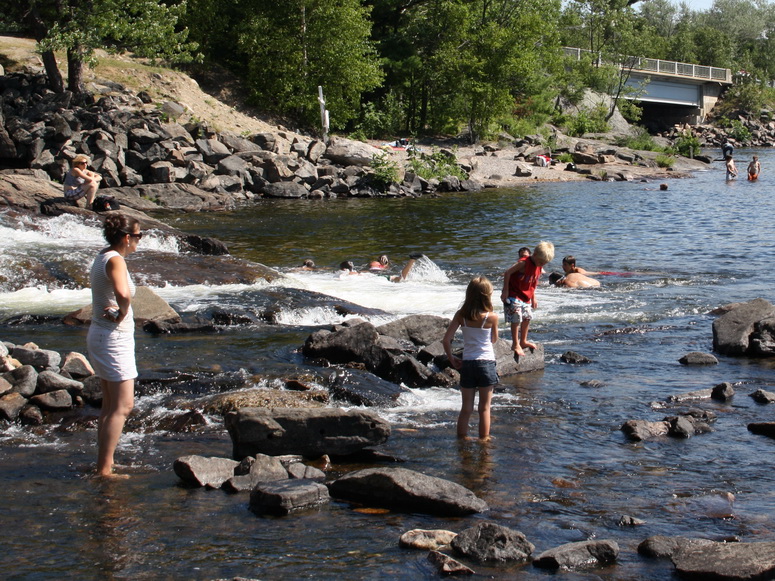
When we have noted to the Ministry of Natural Resources that the treacherously-turbulent water exiting the proposed hydro-electric generating station at the Bala falls would be extremely dangerous to the in-water recreation at the base of the Bala north falls. The MNR says “It is commonly recognized that swimming, wading or other water‐based activities below a water control structure such as the Bala North dam are not advisable recreational practices”.

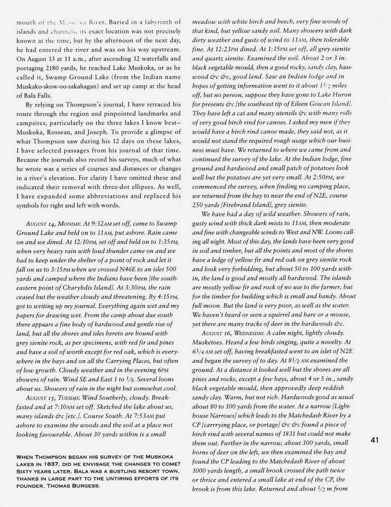
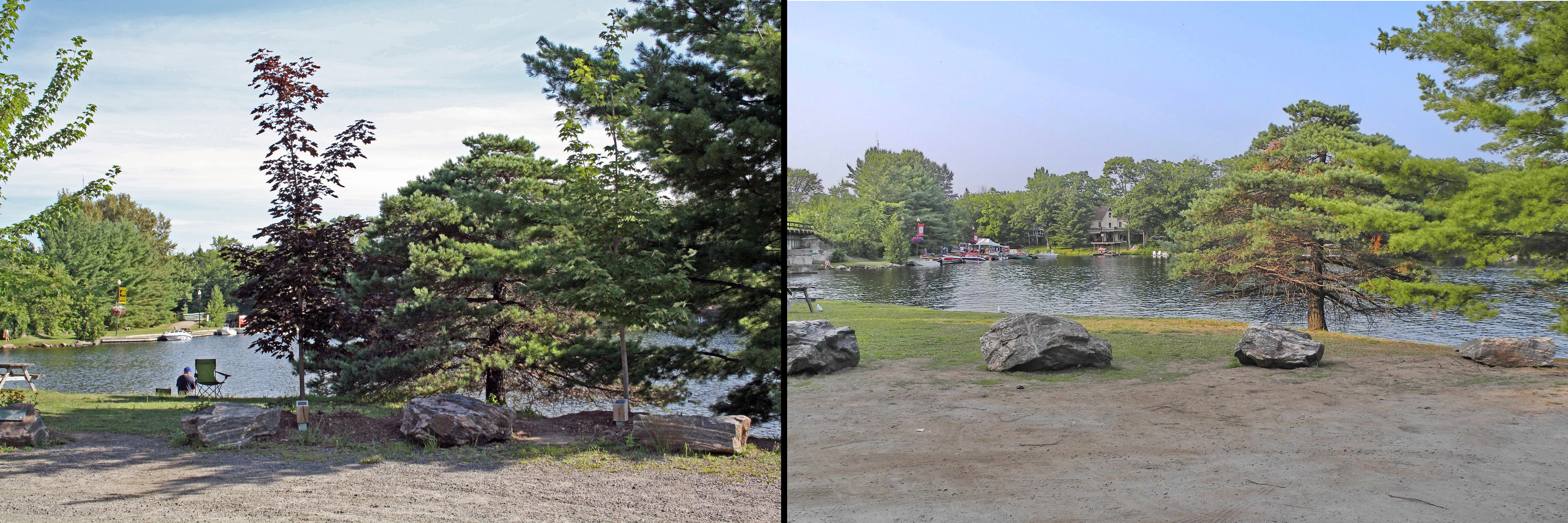
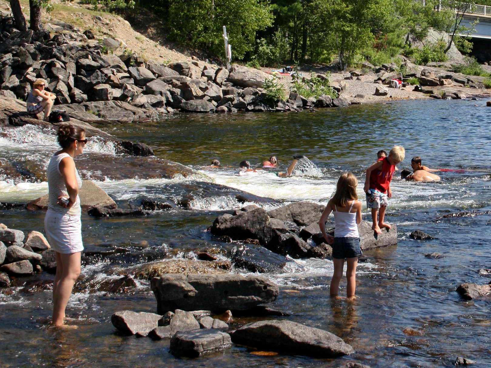
The photograph below was taken below the Bala north dam. Obviously it can be safe playing in the water below the Bala north dam. Nothing here can change suddenly. This is exactly what draws people to Bala and why the Bala falls are famous. This is an important factor in the local economy. This is natural. This is an experience to be remembered for a lifetime. This is Canada, this is an important part of our culture. And being able to judge natural water features to be safe is an important part of growing up.

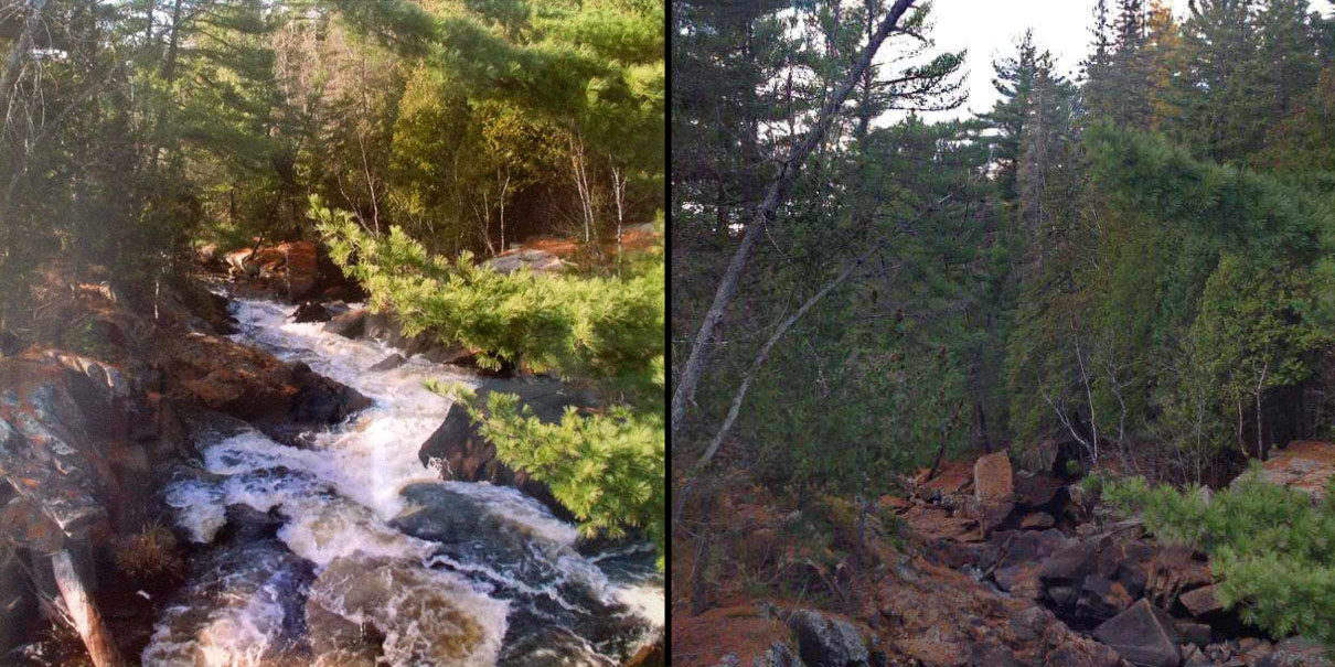
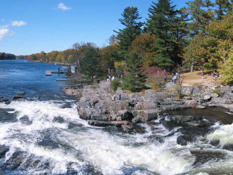
And as shown by the photograph below, being able to sit on natural rock, with a clear view of a beautiful river is also what draws people to Bala. Unlike most every other waterfalls in the area, the Bala Falls are accessible, there is an adjacent road and park, there is parking, there are shops and restaurants. This is important to be maintained.

The MNR states that it would be the proponent’s responsibility “to ensure appropriate public safety measures are in place as they relate to the flows”. Given the dangerous flows from the proposed generating station direclty adjacent to the Bala falls, there is only one way to try to make this safe – put a fence around Margaret Burgess Park to prevent people from accessing the water.

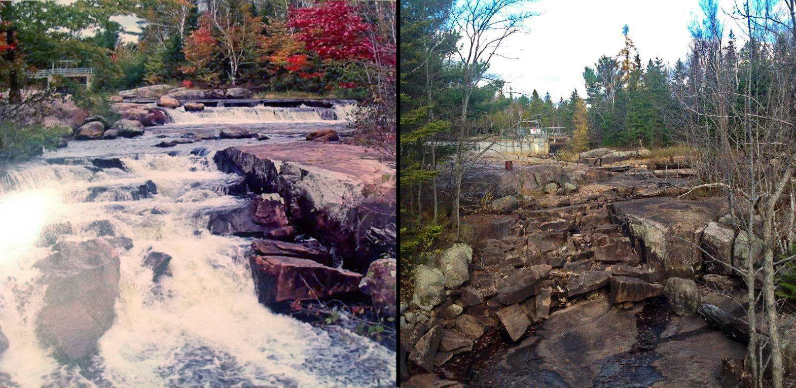
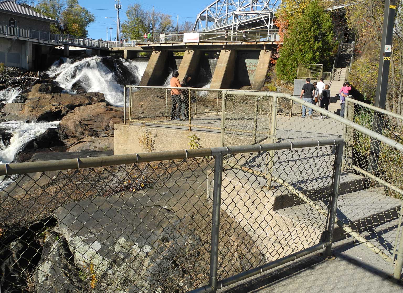
As shown in the photograph below, for a long time there has been fencing all around the Bracebridge Falls (the generating station there has only ⅓ of the flow of that proposed for Bala, and is operated by the same company that would operate the proposed Bala generating station – so they certainly understand how to put concrete and fencing on natural rock, and believe it is necessary).

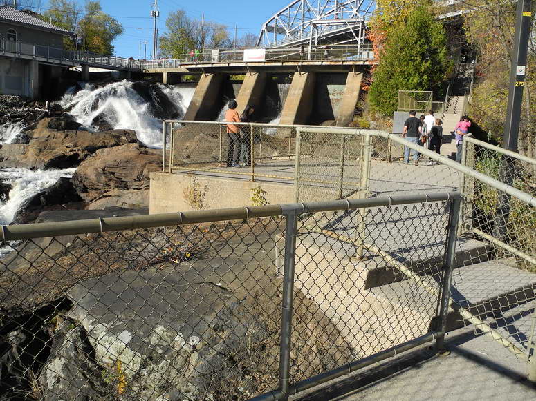
Therefore, the proponent’s current plans would require that all of Margaret Burgess Park be fenced-off to prevent people from accessing the water. This would be ugly, it would permanently remove a main draw of people to Bala and reduce the benefit of tourism to the local economy.


Quick Current Summary

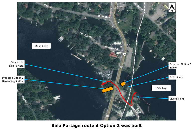
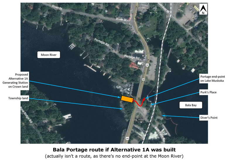
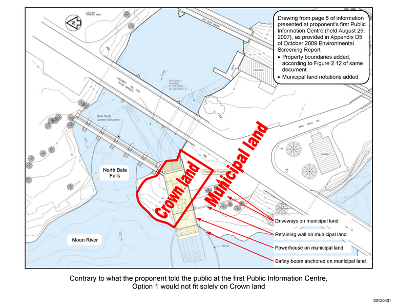
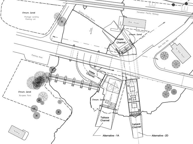
  • Ignoring many serious questions of public safety, law, and process, it was announced in January 2013 that the Minister of the Environment would not vary his Director’s decision. So for now, the proponent has one of the many approvals they would need to proceed with their proposed Alternative 1A, which they claim could be built solely on the Crown land south of the north Bala Falls, and which would be substantially closer to, and angled towards the in-water recreational area at the base of the North Falls.
  • There are many other approvals needed – from all four levels of government and from other organizations as well.
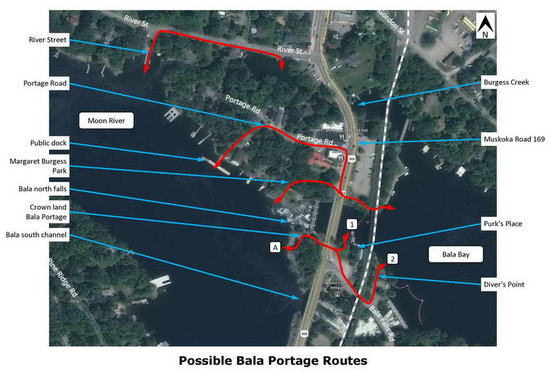
  • A significant approval needed from the Ministry of Natural Resources is Location Approval, under the Lakes and Rivers Improvement Act. One major issue is that the traditional and historic portage through Bala has been shown to be over the Crown land south of the north falls (detail here and here), and information from both the MNR and proponent have confirmed the existence of this portage route. The proposed hydro-electric generating station would obstruct this portage, and blocking a portage that “has existed or exists” is not allowed under the Public Lands Act. Remarkably, the provincial government feels that such rules do not apply to them, and they can just declare the land unsafe, and somehow they no longer need to protect the portage.

Recent Development
Now it gets interesting

On January 23, 2013, the Ministry of the Environment released the decision that the Minister of the Environment decided not to vary his Director’s decision which denied our many requests that the proposed project to build a hydro-electric generating station at the Bala Falls requires elevation to address many significant and serious issues. Our observations include:

  1. This is just one of many approvals this proposed project would need, these from all four levels of government and from other organizations as well. We will continue to highlight the safety, economic and other concerns.
  2. The decisions made by the Minister of the Environment avoided addressing many major issues of law, some of these decisions were based on information from the Ministry of Natural Resources.
  3. The Ontario Liberal government’s process is backwards, in that once they select an “Applicant of Record” to develop a site, they feel there a committment to provide all subsequent environmental and other approvals regardless of how unsuitable the site may then be found to be. So rather than first checking whether a project can be done safely to the environment and people, a developer is selected and the politicians then override all fact, science, and policy for fear of being sued or scaring away developers from future projects.

As always, if you have any questions or comments, contact us at info@SaveTheBalaFalls.com

Jul 262014
 

Summary

The proponent’s current plans are to obstruct the historic and traditional Bala Portage between the Moon River and Lake Muskoka. Transport Canada and others claim there are other, perhaps even safer, alternatives. However there are major problems with each:

  • The River Street route requires paddling under the Muskoka Road 169 bridge over Burgess Creek and as the opening is narrow, the water speed is too fast for many to safely paddle upstream.
  • The Portage Street route requires a 90° turn at Muskoka Road 169 and if there’s a parked car at this turn, your canoe extends into the southbound lane of traffic.
  • The Margaret Burgess Park route would not be possible as it would be fenced-off during construction, and apparently during operation as well.

More concerns are below.


Detail

In a letter dated September 18, 2012, concerning the proposed hydro-electric generating station in Bala, and under the heading “Portage”, Transport Canada stated:

  • “The revised [Alternative 1A proposal] will impact the downstream side portage trail adjacent to the north falls, however, there are reasonable alternatives to this trail including what we consider as the primary portage through the Municipal public lands/park to the North of the falls and utilizng the downstream public park and dock as a put in/take out location.”
  • “Downstream it is quite likely that a new access trail/path may, over time, result on the municipal lands south of the proposed [generating station] – as it is the shortest distance from upstream to downstream. The slope there is similar to the existing path, which is considered as very steep and not the [Transport Canada] recommended portage.”

The above appears to have several errors or misunderstandings, specifically:

  • “the Municipal public lands/park to the North of the falls”, perhaps this refers to Margaret Burgess Park, which is to the north of the falls, but is actually owned by the Ministry of Natural Resources.
  • “downstream public park and dock”, perhaps this refers to the Town Docks on the Moon River, but there is no public park there (and the MNR refuses to refer to Margaret Burgess Park as a park).
  • “The slope there is similar to the existing path”, no the slope on the Township land is much steeper than on the Crown land, and it is not possible to portage a canoe at this suggested alternate location.

That is, Transport Canada seems to simply not understand the area, which certainly indicates they never portaged a canoe in any of the locations they suggest. Their recommendations therefore are not credible. This is exactly why it is important that Transport Canada be required to accept public input as part of their assessment of the proponent’s application under the Navigation Protection Act.

In any case, the only possible portages through Bala are as shown below (click for a larger view).

Each of the above labelled possible portage routes is evaluated below.

  1. River Street, problems include:
    • As the opening under the Muskoka Road 169 bridge over Burgess Creek is quite narrow, when the Burgess Creek generating station is running, the water under the bridge is too fast for weaker or inexperienced paddlers to canoe through, especially upstream. YMCA Camp Pine Crest (in Torrance) has stated that this section of fast water is so dangerous that they do not permit their canoe trips to use this route in either direction.
    • It is not known who owns the portage landing site upstream of the Burgess Creek generating station.
    • The upstream safety boom for the Burgess Creek generating station is too close to the generating station, is not the required current design, and is not designed to facilitate self-rescue (that is, it does not angle towards a safe shore).
    • There is no shoulder on River Street, so it is dangerous to portage canoes along the road.
  2. Portage Street, problems include:
    • The route between Portage Street and the Moon River passes over private property, so this cannot be considered a public portage. In addition, River Street has never been conveyed to the municipality, so it isn’t clear whether portaging is allowed anywhere along the street.
    • The road has no sidewalks or even a shoulder, and there are buildings directly beside Portage Street, so portaging must be on the road. And at Muskoka Road 169, one must either walk between parked cars or make a 90° turn, so one’s canoe must extend into the southbound lane of Muskoka Road 169 when making this turn. This is dangerous.
    • Muskoka Road 169 curves just north of the Portage Street intersection, so it is not possible for portagers to see cars approaching from the north and vice versa. This is dangerous.
    • Canoes must be portaged along Muskoka Road 169, which has a speed limit of 50 km/h. The backdraft from large trucks travelling at this speed could spin around canoes being portaged, which would be very dangerous.
    • One cannot portage alongside the Bala north channel because the CPR rail bridge is too low.
    • If the proposed generating station was built, the Bala Bay end of the portage would have water currents drawing canoes into the station’s intake, which would be dangerous.
    • During the summer, there are usually many motorboats at and near Bala Wharf, so it is better for canoes to be away from this area.
  3. Margaret Burgess Park, problems include:
    • Climbing up the rocks while portaging a canoe would be dangerous.
    • From the water flow simulation information provided by the proponent, it appears that canoeing in front of Margaret Burgess Park would be difficult and dangerous, due to the fast water which would often be exiting from the proposed generating station.
    • One cannot portage alongside the Bala north channel because the CPR rail bridge is too low.
    • During the summer, there are usually many motorboats at and near Bala Wharf, so it is better for canoes to be away from this area.
    • If the proposed generating station was built:
      • During construction, Margaret Burgess Park would be used for equipment and materials storage, so could not be used for portaging.
      • During operation, there would apparently be a fence along the shore of Margaret Burgess Park, so it would not be possible to portage. And the Bala Bay end of the portage would be just upstream of the station’s 40′-deep intake, which would be an dangerous area.
  4. The Bala Portage, as documented (for example herehere, and here), the traditional and historic Bala Portage has always been south of what is now called the Bala north falls.
    As documented here, the exact route (somewhere between the Bala north falls and the Bala south channel) would have changed over the years due to the construction of the railway in 1907 and the highway bypass in 1965. Until the MNR’s May 2013 restriction on the public using the Crown land, for at least the last 50 years, the Bala Portage route between A and 1 (shown above) was used. Note the following:
    • This is the shortest, simplest, most direct route, with dirt surfaces on either side of the road as that causes the least damage if the canoe needs to be put down or rested while repositioning one’s shoulders.
    • This is the safest route, as:
      • It does not require walking along any roads.
      • There is ample room to wait beside the road and there is a clear view down the straight section of Muskoka Road 169 in both directions to be sure it is safe to cross.
      • There are no parked cars to obstruct the view in either direction.
      • The road is directly crossed, not on an angle or requiring a turn.
    • If the proposed generating station was built, the end-point beside Purk’s Place (at 1) would be just upstream of the 40′-deep intake, which would be an extremely dangerous place to be, so this should not be used.
    • Diver’s Point (end-point at 2) could be used as an alternate to 1, but the Bala Falls Road underpass below the CPR railway is very narrow and is also used by cars, so this would be dangerous.
    • If the proposed generating station was built, then the portage route to the Moon River would be obstructed. A safe alternative has not been proposed.

Comments from people who have used each of these possible portage routes are welcome.

Jul 252014
 

The Ministry of Natural Resources’ 2004/2005 Competitive Site Release for the North Bala Dam was for the Crown land south of the Bala north falls (“Proposed site”, below), which has an area of 765 m².

However, the MNR intends to also release to the proponent – in perpetuity – the three other Crown lands sites they own in Bala (click for a larger view).

These other sites have a total area of 3,190 m². So not only does the MNR plan on releasing more than five times the public land they originally disclosed, but most all the public land in Bala become controlled by a private developer.

So if the developer’s operator, or lawyers, or insurance company told them the public could fall climbing the rocks in Margaret Burgess Park or get sucked-into the proposed water intake downstream of the land beside Purk’s Place, the developer could fence off these areas from public access. Or if they felt this didn’t reduce their liability enough, they could use barbed-wire fencing, as is already installed at all three of the generating stations at and north of Bracebridge Falls.

And if you think that Bala is too beautiful and nobody would ever install barbed-wire fencing, the decision to use barbed-wire fencing in Bracebridge was made by Bracebridge Generation, the same company that would operate the proposed Bala hydro-electric generating station.

Jul 242014
 

1) The proponent’s first proposal was in 2005, to the Ministry of Natural Resources. They were responding to an opportunity that would only make available the Crown land south of the Bala north falls. However, as shown in their drawing below (notations added, click on it for a larger view), their proposal actually required substantial portions of the municipal land to the south. That is, while they said their Option 1 proposal only required Crown land, clearly it needed municipal land as well.

2) Beginning in 2008, the proponent proposed their Option 2 (referred to as Alternative 2D in their figure below). This required even more municipal land to the south of the Crown land, and the intake would be on the east side of Muskoka Road 169.

3) Beginning in 2012, the proponent proposed their Alternative 1A proposal, which was the first proposal that could apparently be built solely on the Crown land south of the Bala north falls. It is also the only proposal which directs the treacherously fast and turbulent water exiting the proposed tailrace closer towards the public and private docks along the north side of the Moon River.


Jul 222014
 

Court Decision

It would certainly have helped meet our goals if the Ontario Court of Appeal had agreed with the Township  of Muskoka Lakes in their recent day in court where they presented their concerns about the Ministry of Natural Resources and the Public Lands Act. So as always, we will continue to ask:

  • Would the proposed station be safe, for the in-water recreation that has been part of Bala for over 100 years, such as swimming and boating upstream and downstream.
  • Would the proposed station be beautiful, as this area is. The few drawings and renderings provided by the proponent have all had such major omissions and errors that they mislead rather than inform. And the proponent won’t commit there would be no barbed-wire fencing or that there would not be warning sirens sounded daily (they only make vague statements about not currently having any such plans).
  • Would there be enough water over the Bala north and south falls that people would continue to be drawn to Bala (nobody will come to see the dry rocks where the falls used to be).
     

Current Situation

As for the last nine years, the proponent still requires approvals from all four levels of government.

  1. Federal government: Transport Canada must provide approval under the Navigation Protection Act before any in-water work can commence. We have many concerns, as stated in this letter, and have asked our federal MP, Minister Tony Clement, to ask that Transport Canada include public consultation in their assessment of this proposed project. While Minister Clement’s initial response seemed to be that this is a provincial issue, as shown here, there will be an impact on marine navigation and we need to have an opportunity to ensure that Transport Canada hears how and by whom these docks are used. Our representation for such federal matters is through our Minister Clement, you can e-mail him at Tony.Clement@parl.gc.ca to let him know your concerns, which may include:
    • This is his issue too, and his constituents are asking him to ensure that Transport Canada hears and understands from the public how these docks are used. For example, often less experienced boaters such as children and visitors use these docks. And people arriving at these docks often go to nearby stores, so the area’s economy would be affected as well.
    • People are used to the faster water typically entering the Moon River from the south channel, not from the proposed new location which is directed towards the most popular in-water recreation areas on the Moon River. And because the proposed generating station would be remotely- and automatically-controlled (cycling on for ⅓ of summer days, and running at full capacity an average of 21 days each summer), people could never know if there is turbulent water from the proposed tailrace and what speed it would be.
       
  2. Provincial government: The Ministry of Natural Resources is currently considering the proponent’s application for Plans and Specifications approval. Unfortunately, there is no requirement for public input into this process, but we continue to provide input to the MNR, for example, that the proponent’s construction would create too high a risk of flooding Lake Muskoka.
     
  3. District Municipality of Muskoka: While the District has recently allowed the proponent “driveway access” for two of the three sites they need, this access isn’t allowed until October 20, and the District hasn’t considered that traffic would be stopped for up to 1½ hours daily during blasting, and that the removal of the guardrail opposite the end of Bala Falls Road would pose dangers to both vehicles and pedestrians.
     
  4. Township of Muskoka Lakes: The proponent requires a building permit and driveway access.

So this is certainly not a “done deal”.
 

To Save the Bala Falls we need to keep communicating

Ask your family and neighbours to sign themselves up for our e-Newsletters at the top-right at SaveTheBalaFalls.com, and follow us on twitter at @SaveBalaFalls and Like us on Facebook at Save the Bala Falls.

SaveTheBalaFalls.com